
Ragiv:Aerial view of downtown Rome, Georgia.jpg

Ragiv rigik (2,511 × 1,729 pixel, ragivagret: 4.29 MB, pated MIME: image/jpeg)
Plän brefik
| Bepenam |
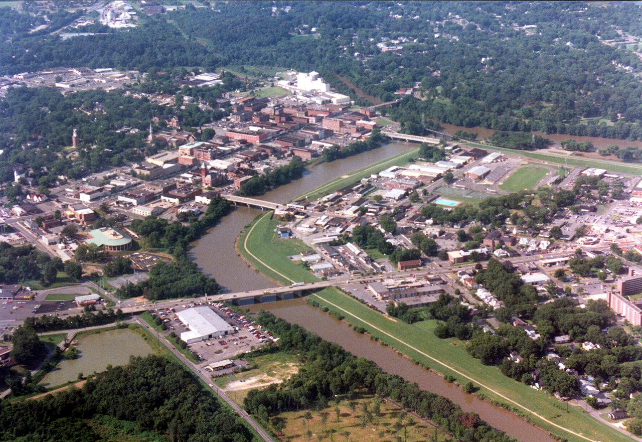
Aerial view of downtown Rome, Georgia, looking South-Southwest. Viewable are Broad Street, several of Rome's seven hills, the three rivers, several major bridges, the Clock Tower, the Old Courthouse, and many other features familiar to Romans. The river in the foreground is the Oostanaula, which flows from the bottom of the photo toward the top, and terminates where it meets the Etowah river, flowing in the from left side. This river junction is the head of the Coosa river, which flows off to the right side, and toward the State of Alabama. Before the city of Rome was established, this area was referred to by the Creek and Cherokee indians as "Head of Coosa". This picture is about twenty years old or more. Much has changed. That big white building in the lower left corner is now an olive garden, starbucks, and various other restaurants and stores. Also, that body of water to the left of it no longer exists. Famous Quote while overlooking a part of Rome: "That's the armpit of America." -Harrison Ford |
| Dät | circa 1980's |
| Fon | John Lambert |
| Lautan | William Fred Lambert, Pilot Jeff Lambert |
| Camera location | | View this and other nearby images on: OpenStreetMap |
|---|
Dälastad

|
Däl pagevon ad kopiedön, seagivön e/u votükön dokümi at ma Dälazöt ad Dokümam Libik: GNU, Fomam: 1.2 u nulikum fa el Free Software Foundation (Stitod: Nünömaprograms libik); nen diläds nevotükovik, nen vödems tegapada balid, e leigo nen vödems tegapada lätik. Kopied dälazöta pekeninon in diläd: Dälazöt ad Dokümam Libik: GNU panemöl. |
| This file is licensed under the Creative Commons Attribution-Share Alike 3.0 Unported license. | ||
| ||
| This licensing tag was added to this file as part of the GFDL licensing update. |
- Binol libik:
- to share – to copy, distribute and transmit the work
- to remix – to adapt the work
- Under the following conditions:
- attribution – You must give appropriate credit, provide a link to the license, and indicate if changes were made. You may do so in any reasonable manner, but not in any way that suggests the licensor endorses you or your use.
- share alike – If you remix, transform, or build upon the material, you must distribute your contributions under the same or compatible license as the original.
Jenotem ragiva
Välolös däti/timi ad logön ragivi soäsä äbinon ün tim at.
| Dät/Tim | Magodil | Mafots | Geban | Küpet | |
|---|---|---|---|---|---|
| anuik | 19:47, 2007 prilul 14id | | 2,511 × 1,729 (4.29 MB) | Jdlambert | {{Information |Description=Aerial view of downtown Rome, Georgia, looking South-Southwest. Viewable are Broad Street, several of Rome's seven hills, the three rivers, several major bridges, the Clock Tower, the Old Courthouse, and many other features fami |
Yüms
Pads sököl payümons ko pad at:
Ragivigeb Valöpik
The following other wikis use this file:
- Geb su de.wikipedia.org
- Geb su en.wikipedia.org
- Geb su fa.wikipedia.org
- Geb su id.wikipedia.org
- Geb su nl.wikipedia.org