
Ragiv:Brohl Panorama Eselstreppe.jpg

Size of this preview: 800 × 229 pixels. Other resolutions: 320 × 91 pixels • 640 × 183 pixels • 1,024 × 293 pixels • 1,280 × 366 pixels • 7,140 × 2,040 pixels.
Ragiv rigik (7,140 × 2,040 pixel, ragivagret: 2.22 MB, pated MIME: image/jpeg)
Plän brefik
| Bepenam |
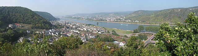
Deutsch: Panoramablick vom Felsenpfad „Eselstreppe“ am Dicktberg auf Brohl-Lützing (Verbandsgemeinde Bad Breisig), den Rhein, Bad Hönningen und Rheinbrohl in Rheinland-Pfalz, Deutschland
|
| Dät | |
| Fon | Vobot okik |
| Lautan | Doris Antony, Berlin |
| Däl (Reusing this file) |
Doris Antony put it under the GFDL and CC-BY-SA-3.0 |
| Camera location | | View this and other nearby images on: OpenStreetMap |
|---|
Dälastad
I, the copyright holder of this work, hereby publish it under the following licenses:

|
Däl pagevon ad kopiedön, seagivön e/u votükön dokümi at ma Dälazöt ad Dokümam Libik: GNU, Fomam: 1.2 u nulikum fa el Free Software Foundation (Stitod: Nünömaprograms libik); nen diläds nevotükovik, nen vödems tegapada balid, e leigo nen vödems tegapada lätik. Kopied dälazöta pekeninon in diläd: Dälazöt ad Dokümam Libik: GNU panemöl. |
This file is licensed under the Creative Commons Attribution-Share Alike 4.0 International, 3.0 Unported, 2.5 Generic, 2.0 Generic and 1.0 Generic license.
- Binol libik:
- to share – to copy, distribute and transmit the work
- to remix – to adapt the work
- Under the following conditions:
- attribution – You must give appropriate credit, provide a link to the license, and indicate if changes were made. You may do so in any reasonable manner, but not in any way that suggests the licensor endorses you or your use.
- share alike – If you remix, transform, or build upon the material, you must distribute your contributions under the same or compatible license as the original.
You may select the license of your choice.
Jenotem ragiva
Välolös däti/timi ad logön ragivi soäsä äbinon ün tim at.
| Dät/Tim | Magodil | Mafots | Geban | Küpet | |
|---|---|---|---|---|---|
| anuik | 20:36, 2009 tobul 2id | 7,140 × 2,040 (2.22 MB) | DorisAntony | {{Information| |Description={{de|Panoramablick vom Felsenpfad „Eselstreppe“ am Dicktberg auf Brohl-Lützing (Verbandsgemeinde Bad Breisig), den Rhein, [[:de:Bad Hönningen|Bad Hönn |
Yüms
Pads nonik peyümons ad ragiv at.
Ragivigeb Valöpik
The following other wikis use this file:
- Geb su ceb.wikipedia.org
- Geb su ce.wikipedia.org
- Geb su de.wikipedia.org
- Geb su es.wikipedia.org
- Geb su eu.wikipedia.org
- Geb su hu.wikipedia.org
- Geb su it.wikipedia.org
- Geb su ku.wikipedia.org
- Geb su ky.wikipedia.org
- Geb su lld.wikipedia.org
- Geb su nl.wikipedia.org
- Geb su pl.wikipedia.org
- Geb su ro.wikipedia.org
- Geb su ru.wikipedia.org
- Geb su sr.wikipedia.org
- Geb su sv.wikipedia.org
- Geb su tt.wikipedia.org
- Geb su uz.wikipedia.org
- Geb su vi.wikipedia.org
- Geb su www.wikidata.org