
Ragiv:LocationNiger.png
Gretot gudikum no pagebidon.
LocationNiger.png (250 × 115 pixel, ragivagret: 7 KB, pated MIME: image/png)
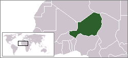
Location map for the Niger.
Originally created for English Wikipedia by Vardion.
| |
This work has been released into the public domain by its author, Vardion, at the Linglänapük Vükiped project. This applies worldwide. In case this is not legally possible: |

|
File:LocationNiger.svg is a vector version of this file. It should be used in place of this PNG file when not inferior.
File:LocationNiger.png → File:LocationNiger.svg
For more information, see Help:SVG. |
 |
Jenotem ragiva
Välolös däti/timi ad logön ragivi soäsä äbinon ün tim at.
| Dät/Tim | Magodil | Mafots | Geban | Küpet | |
|---|---|---|---|---|---|
| anuik | 22:28, 2011 gustul 30id | | 250 × 115 (7 KB) | Hoshie | added South Sudan |
| 14:16, 2007 dekul 4id |  | 250 × 115 (6 KB) | Gandal el gris | Sahara is not Morocco | |
| 14:15, 2007 dekul 4id |  | 250 × 115 (5 KB) | Gandal el gris | Reverted to version as of 11:29, 4 December 2007 | |
| 14:14, 2007 dekul 4id |  | 250 × 115 (6 KB) | Gandal el gris | Reverted to version as of 07:02, 19 November 2007 | |
| 11:29, 2007 dekul 4id |  | 250 × 115 (5 KB) | Tetouancity | Reverted to version as of 11:58, 15 November 2007 | |
| 07:02, 2007 novul 19id |  | 250 × 115 (6 KB) | Gandal el gris | ||
| 11:58, 2007 novul 15id |  | 250 × 115 (5 KB) | Vispec | ||
| 22:09, 2004 dekul 12id |  | 250 × 115 (6 KB) | EugeneZelenko | Location map for the Niger.<br/>Originally created for English Wikipedia by Vardion.<br/>{{PD}}<br/>Category:Country locator maps |
Yüms
Pads sököl payümons ko pad at:
Ragivigeb Valöpik
The following other wikis use this file:
- Geb su arc.wikipedia.org
- Geb su ar.wikipedia.org
- Geb su bg.wikipedia.org
- Geb su bm.wikipedia.org
- Geb su bpy.wikipedia.org
- Geb su bs.wikipedia.org
- Geb su ca.wikinews.org
- Geb su ceb.wikipedia.org
- Geb su de.wikipedia.org
- Geb su de.wikinews.org
- Geb su de.wikivoyage.org
- Geb su de.wiktionary.org
- Geb su en.wikipedia.org
- Geb su en.wikivoyage.org
- Geb su en.wiktionary.org
- Geb su eo.wikipedia.org
- Geb su es.wikipedia.org
- Geb su frp.wikipedia.org
- Geb su fr.wikipedia.org
- Geb su he.wikivoyage.org
- Geb su hif.wikipedia.org
- Geb su hr.wiktionary.org
- Geb su ig.wikipedia.org
- Geb su incubator.wikimedia.org
View more global usage of this file.