
Ragiv:Neerpelt Limburg Belgium Map.png
Gretot gudikum no pagebidon.
Neerpelt_Limburg_Belgium_Map.png (270 × 203 pixel, ragivagret: 5 KB, pated MIME: image/png)

|
File:Neerpelt Limburg Belgium Map.svg is a vector version of this file. It should be used in place of this PNG file when not inferior.
File:Neerpelt Limburg Belgium Map.png → File:Neerpelt Limburg Belgium Map.svg
For more information, see Help:SVG. |
 |
Plän brefik
| Bepenam |
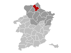
Brezhoneg: Lec'hiañ Neerpelt, Belgia.
English: Map, municipality belgium Neerpelt.
Français : Carte indiquant la localisation de la commune de Neerpelt dans la Province de Limbourg. |
| Fon | Vobot okik, originally from w:nl:Gebruiker:LennartBolks/kaartenhoekje. |
| Lautan | LennartBolks |
Dälastad
| This work has been released into the public domain by its author, LennartBolks. This applies worldwide. In some countries this may not be legally possible; if so: |
Jenotem ragiva
Välolös däti/timi ad logön ragivi soäsä äbinon ün tim at.
| Dät/Tim | Magodil | Mafots | Geban | Küpet | |
|---|---|---|---|---|---|
| anuik | 00:49, 2006 prilul 12id | | 270 × 203 (5 KB) | Profoss | |
| 10:44, 2005 prilul 9id |  | 270 × 203 (4 KB) | Nicnac25~commonswiki | Map, municipality belgium Neerpelt {{PD}} FR; Carte indiquant la localisation de la commune de Neerpelt dans la Province de Limbourg. EN; Map from w:nl:Gebruiker:LennartBolks/kaartenhoekje in Public Domain by the Author choice. [[Category:Maps of pro |
Yüms
Pads nonik peyümons ad ragiv at.
Ragivigeb Valöpik
The following other wikis use this file:
- Geb su af.wikipedia.org
- Geb su ar.wikipedia.org
- Geb su ca.wikipedia.org
- Geb su el.wikipedia.org
- Geb su eo.wikipedia.org
- Geb su es.wikipedia.org
- Geb su eu.wikipedia.org
- Geb su it.wikipedia.org
- Geb su li.wikipedia.org
- Geb su nl.wikipedia.org
- Geb su pt.wikipedia.org
- Geb su ro.wikipedia.org
- Geb su th.wikipedia.org
- Geb su vi.wikipedia.org
- Geb su www.wikidata.org