
Ragiv:Nunavut-map.png
Gretot gudikum no pagebidon.
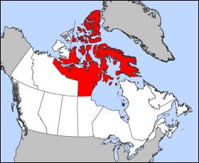
Nunavut-map.png (280 × 230 pixel, ragivagret: 15 KB, pated MIME: image/png)

|
File:Nunavut, Canada.svg is a vector version of this file. It should be used in place of this PNG file when not inferior.
File:Nunavut-map.png → File:Nunavut, Canada.svg
For more information, see Help:SVG. |
 |
Map of Nunavut
Projection: Lambert azimuthal equal-area
Geospatial data from: The Atlas of Canada, The National Atlas of the United States and U.S. Geological Survey
Cartographer: John Fowler
| I, the copyright holder of this work, release this work into the public domain. This applies worldwide. In some countries this may not be legally possible; if so: I grant anyone the right to use this work for any purpose, without any conditions, unless such conditions are required by law. |
Jenotem ragiva
Välolös däti/timi ad logön ragivi soäsä äbinon ün tim at.
| Dät/Tim | Magodil | Mafots | Geban | Küpet | |
|---|---|---|---|---|---|
| anuik | 12:16, 2005 mäzul 24id | | 280 × 230 (15 KB) | Voyager | Map of Nunavut Projection: Lambert azimuthal equal-area Geospatial data from: [http://atlas.gc.ca/ The Atlas of Canada], [http://www.nationalatlas.gov/ The National Atlas of the United States] and [http://www.usgs.gov U.S. Geological Survey] Cartograph |
Yüms
Pads sököl payümons ko pad at:
Ragivigeb Valöpik
The following other wikis use this file:
- Geb su bat-smg.wikipedia.org
- Geb su br.wikipedia.org
- Geb su ceb.wikipedia.org
- Geb su cy.wikipedia.org
- Geb su da.wikipedia.org
- Geb su el.wikipedia.org
- Geb su el.wikivoyage.org
- Geb su en.wikipedia.org
- Geb su en.wikinews.org
- Geb su en.wikivoyage.org
- Geb su en.wiktionary.org
- Geb su eo.wikipedia.org
- Geb su es.wikipedia.org
- Geb su es.wiktionary.org
- Geb su fi.wikipedia.org
- Geb su fi.wikivoyage.org
- Geb su frr.wikipedia.org
- Geb su fr.wikipedia.org
- Geb su fr.wikinews.org
- Geb su fr.wiktionary.org
- Geb su gd.wikipedia.org
- Geb su hu.wikipedia.org
- Geb su hy.wikipedia.org
- Geb su io.wikipedia.org
- Geb su iu.wikipedia.org
- Geb su kw.wikipedia.org
- Geb su lij.wikipedia.org
- Geb su ms.wikipedia.org
- Geb su nl.wikipedia.org
- Geb su nn.wikipedia.org
- Geb su pam.wikipedia.org
- Geb su pms.wikipedia.org
- Geb su sh.wikipedia.org
- Geb su sv.wikipedia.org
- Geb su zh-min-nan.wikipedia.org