
Ragiv:Sacramento Skyline (cropped).jpg

Ragiv rigik (4,030 × 1,127 pixel, ragivagret: 1.3 MB, pated MIME: image/jpeg)
.jpg)
Plän brefik
| Bepenam |
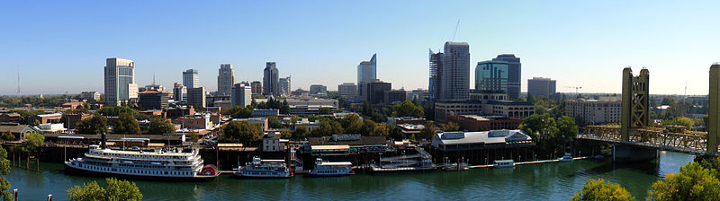
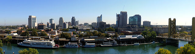
English: The Sacramento skyline, as seen from The Ziggurat in West Sacramento, California. The building is occupied by California Department of General Services who were very generous in their time in permitting me use their balcony.
Français : Le centre-ville de Sacramento, en Californie (États-Unis) vu depuis le sommet du building The Ziggurat, à West Sacramento. |
| Dät | |
| Fon | Vobot okik |
| Lautan | J.smith |
| Other versions |
 |
| Camera location | | View this and other nearby images on: OpenStreetMap |
|---|
.jpg¶ms=038.582861_N_-121.509389_E_globe:Earth_type:camera_heading:90.00&language=vo)
Dälastad
- Binol libik:
- to share – to copy, distribute and transmit the work
- to remix – to adapt the work
- Under the following conditions:
- attribution – You must give appropriate credit, provide a link to the license, and indicate if changes were made. You may do so in any reasonable manner, but not in any way that suggests the licensor endorses you or your use.
- share alike – If you remix, transform, or build upon the material, you must distribute your contributions under the same or compatible license as the original.

|
This image has been assessed under the valued image criteria and is considered the most valued image on Commons within the scope: Sacramento. You can see its nomination here. |
.jpg)
 |
This photo was taken by Justin Smith (User:J.smith) and released under the license(s) stated on this page. You are free to use this image as long as you follow the terms of the license and credit me properly. Example: © Justin Smith / Wikimedia Commons, CC-By-SA-3.0 If you use this image outside of Wikimedia projects I would appreciate (but do not require) being informed. If you would like a license with the conditions of your choice, please e-mail (commons's build-in system or at jsmith |
 |
Jenotem ragiva
Välolös däti/timi ad logön ragivi soäsä äbinon ün tim at.
| Dät/Tim | Magodil | Mafots | Geban | Küpet | |
|---|---|---|---|---|---|
| anuik | 00:13, 2011 febul 25id | 4,030 × 1,127 (1.3 MB) | 08OceanBeach SD | brightened | |
| 02:00, 2008 tobul 17id | 4,030 × 1,127 (1.14 MB) | J.smith | {{Information |Description={{en|1=The Sacramento skyline, as seen from The Ziggurat in West Sacramento, California. The building is owned and occupied by California Department of General Services wh |
Yüms
Pads sököl payümons ko pad at:
Ragivigeb Valöpik
The following other wikis use this file:
- Geb su ar.wikipedia.org
- Geb su ast.wikipedia.org
- Geb su azb.wikipedia.org
- Geb su bg.wikipedia.org
- Geb su bn.wikipedia.org
- Geb su ca.wikipedia.org
- Geb su ckb.wikipedia.org
- Geb su cs.wikipedia.org
- Geb su dag.wikipedia.org
- Geb su da.wikipedia.org
- Geb su de.wikipedia.org
- Geb su el.wikipedia.org
- Geb su en.wikipedia.org
- Sacramento, California
- Northern California
- West Coast of the United States
- List of California urban areas
- List of United States cities by population
- Downtown Sacramento
- Talk:Sacramento, California/Archive 1
- Sacramento metropolitan area
- User:Starstriker7/Sacramento Worklist
- User:08OceanBeach SD/Sandbox
- 2015 Tour of California
- User:EC35/sandbox
- Geb su eo.wikipedia.org
- Geb su et.wikipedia.org
- Geb su eu.wikipedia.org
- Geb su fa.wikipedia.org
- Geb su fi.wikipedia.org
- Geb su fo.wikipedia.org
- Geb su fr.wikipedia.org
- Geb su hi.wikipedia.org
- Geb su hu.wikipedia.org
- Geb su hy.wikipedia.org
- Geb su hyw.wikipedia.org
- Geb su it.wikipedia.org
- Geb su ja.wikipedia.org
- Geb su lb.wikipedia.org
- Geb su li.wikipedia.org
- Geb su lld.wikipedia.org
- Geb su ml.wikipedia.org
- Geb su mr.wikipedia.org
View more global usage of this file.
.jpg)
.jpg)