
Ragiv:UTMap-doton-Ogden.PNG
Gretot gudikum no pagebidon.
UTMap-doton-Ogden.PNG (238 × 300 pixel, ragivagret: 19 KB, pated MIME: image/png)
Plän brefik
| Bepenam |
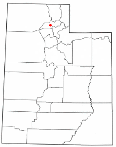
Locator map of Ogden city, in the Ogden Valley, in Utah.
Adapted from Wikipedia's UT county maps by Seth Ilys. |
| Dät | 20 mayul 2004 (original upload date) |
| Fon | Transferred from en.wikipedia to Commons. |
| Lautan | The original uploader was Seth Ilys at Linglänapük Vükiped. |
Dälastad
| This file is licensed under the Creative Commons Attribution-Share Alike 3.0 Unported license. Subject to disclaimers. | ||
| ||
| This licensing tag was added to this file as part of the GFDL licensing update. |

|
Däl pagevon ad kopiedön, seagivön e/u votükön dokümi at ma Dälazöt ad Dokümam Libik: GNU, Fomam: 1.2 u nulikum fa el Free Software Foundation (Stitod: Nünömaprograms libik); nen diläds nevotükovik, nen vödems tegapada balid, e leigo nen vödems tegapada lätik. Kopied dälazöta pekeninon in diläd: Dälazöt ad Dokümam Libik: GNU panemöl. Subject to disclaimers. |
Original upload log
The original description page was here. All following user names refer to en.wikipedia.
- 2004-05-20 21:23 Seth Ilys 238×300×8 (19024 bytes) {{msg:GFDL}}<br>Adapted from Wikipedia's UT county maps by Seth Ilys.
Jenotem ragiva
Välolös däti/timi ad logön ragivi soäsä äbinon ün tim at.
| Dät/Tim | Magodil | Mafots | Geban | Küpet | |
|---|---|---|---|---|---|
| anuik | 13:48, 2007 yulul 13id | | 238 × 300 (19 KB) | SieBot | {{Information |Description=<br>Adapted from Wikipedia's UT county maps by Seth Ilys. |Source=Originally from [http://en.wikipedia.org en.wikipedia]; description page is/was [http://en.wikipedia.org/w/index.php?title=Image%3AUTMap-doton-Ogden.PNG here]. | |
Yüms
Pads nonik peyümons ad ragiv at.
Ragivigeb Valöpik
The following other wikis use this file:
- Geb su cs.wikipedia.org
- Geb su fa.wikipedia.org
- Geb su id.wikipedia.org
- Geb su it.wikipedia.org
- Geb su sh.wikipedia.org
- Geb su sr.wikipedia.org
- Geb su sv.wikipedia.org
- Geb su zh.wikipedia.org