
Ragiv:Baelen Liège Belgium Map.png
Gretot gudikum no pagebidon.
Baelen_Liège_Belgium_Map.png (290 × 220 pixel, ragivagret: 5 KB, pated MIME: image/png)

|
File:Baelen Liège Belgium Map.svg is a vector version of this file. It should be used in place of this PNG file when not inferior.
File:Baelen Liège Belgium Map.png → File:Baelen Liège Belgium Map.svg
For more information, see Help:SVG. |
 |
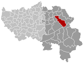
Maps, municipality belgium Baelen
| This work has been released into the public domain by its author, LennartBolks. This applies worldwide. In some countries this may not be legally possible; if so: |
FR; Carte indiquant la localisation de la commune de Baelen dans la Province de Liège.
EN; Map from w:nl:Gebruiker:LennartBolks/kaartenhoekje in Public Domain by the Author choice.
Jenotem ragiva
Välolös däti/timi ad logön ragivi soäsä äbinon ün tim at.
| Dät/Tim | Magodil | Mafots | Geban | Küpet | |
|---|---|---|---|---|---|
| anuik | 14:44, 2008 setul 6id | | 290 × 220 (5 KB) | Ludger1961 | |
| 18:33, 2005 mäzul 21id |  | 290 × 220 (5 KB) | Srtxg | Maps, municipality belgium Baelen {{PD}} FR; Carte indiquant la localisation de la commune de Baelen dans la Province de Liège. EN; Map from w:nl:Gebruiker:LennartBolks/kaartenhoekje in Public Domain by the Author choice. [[Category:Maps of province |
Yüms
Pads nonik peyümons ad ragiv at.