
Ragiv:DHK-map.png
Gretot gudikum no pagebidon.
DHK-map.png (330 × 354 pixel, ragivagret: 16 KB, pated MIME: image/png)
Plän brefik
| Bepenam |
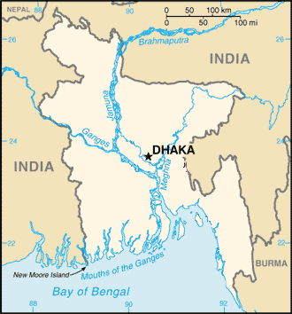
English: This file was created by Arman Aziz on Feb 04, 2007. |
| Dät | 3 febul 2007 (original upload date) |
| Fon | Transferred from en.wikipedia to Commons. |
| Lautan | Armanaziz at Linglänapük Vükiped |
Dälastad
| This work has been released into the public domain by its author, Armanaziz at Linglänapük Vükiped. This applies worldwide. In some countries this may not be legally possible; if so: Armanaziz grants anyone the right to use this work for any purpose, without any conditions, unless such conditions are required by law. |
Original upload log
The original description page was here. All following user names refer to en.wikipedia.
- 2007-02-03 17:58 Armanaziz 330×354×8 (16600 bytes) This file was created by Arman Aziz on Feb 04, 2007.
Jenotem ragiva
Välolös däti/timi ad logön ragivi soäsä äbinon ün tim at.
| Dät/Tim | Magodil | Mafots | Geban | Küpet | |
|---|---|---|---|---|---|
| anuik | 19:45, 2008 febul 26id | | 330 × 354 (16 KB) | Andronicus92 | {{Information |Description={{en|This file was created by Arman Aziz on Feb 04, 2007. en:Category:Maps of Bangladesh}} |Source=Transferred from [http://en.wikipedia.org en.wikipedia] |Date=2007-02-03 (original upload date) |Author=Original uploader |
Yüms
Pads sököl payümons ko pad at:
Ragivigeb Valöpik
The following other wikis use this file:
- Geb su arz.wikipedia.org
- Geb su bxr.wikipedia.org
- Geb su en.wikiquote.org
- Geb su fy.wikipedia.org
- Geb su hr.wikipedia.org
- Geb su ia.wikipedia.org
- Geb su lb.wikipedia.org
- Geb su mi.wikipedia.org
- Geb su ro.wikipedia.org
- Geb su www.wikidata.org