
Ragiv:Forchtenstein - Burg (2).JPG

Size of this preview: 800 × 533 pixels. Other resolutions: 320 × 213 pixels • 640 × 427 pixels • 1,024 × 683 pixels • 1,280 × 853 pixels • 2,560 × 1,706 pixels • 4,139 × 2,759 pixels.
Ragiv rigik (4,139 × 2,759 pixel, ragivagret: 9.59 MB, pated MIME: image/jpeg)
Plän brefik
| Bepenam |
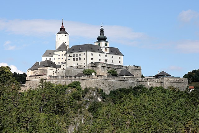
Deutsch: Südostansicht der Burg Forchtenstein in Neustift an der Rosalia, ein Ortsteil der burgenländischen Gemeinde Forchtenstein. Die Burg befindet sich auf einem steilen Dolomitfelsen am Ostabhang des Rosaliengebirges und sicherte die Straßenverbindung Wr. Neustadt - Ödenburg (heutiges Sopron). Sie wurde ab dem 14. Jahrhundert von den Grafen von Mattersdorf errichtet. Nachdem die Burg 1626 in den Besitz der Esterházy gelangte, wurde sie im 17. Jahrhundert umfangreich um- und ausgebaut. |
| Dät | |
| Fon | Vobot okik |
| Lautan | C.Stadler/Bwag |
| Däl (Reusing this file) |
Deutsch: Hallo, du darfst mein Foto kostenlos nutzen, aber nenne mich bitte als Fotograf, beispielsweise „Foto: C.Stadler/Bwag“ oder © C.Stadler/Bwag; CC-BY-SA-4.0. Auf mehr Angaben bestehe ich nicht - im Gegensatz zu manch anderen, die die Vorgaben der unten angeführten Lizenzierung auf Punkt und Beistrich einfordern. English: Feel free to use my photos, but please mention me as the author like © C.Stadler/Bwag or © C.Stadler/Bwag; CC-BY-SA-4.0 (that's good enough) and if you want send me a message: bwag@gmx.net. |
| Other versions |
|
.JPG)
.JPG)
.JPG)
.JPG)
.JPG)
.JPG)
| Object location | | View this and other nearby images on: OpenStreetMap |
|---|
.JPG¶ms=047.709830_N_0016.331740_E_globe:Earth_class:object_type:object__&language=vo)
| Camera location | | View this and other nearby images on: OpenStreetMap |
|---|
.JPG¶ms=047.706611_N_0016.337639_E_globe:Earth_type:camera_heading:310.00&language=vo)
Dälastad
I, the copyright holder of this work, hereby publish it under the following license:
This file is licensed under the Creative Commons Attribution-Share Alike 4.0 International license.
- Binol libik:
- to share – to copy, distribute and transmit the work
- to remix – to adapt the work
- Under the following conditions:
- attribution – You must give appropriate credit, provide a link to the license, and indicate if changes were made. You may do so in any reasonable manner, but not in any way that suggests the licensor endorses you or your use.
- share alike – If you remix, transform, or build upon the material, you must distribute your contributions under the same or compatible license as the original.
Jenotem ragiva
Välolös däti/timi ad logön ragivi soäsä äbinon ün tim at.
| Dät/Tim | Magodil | Mafots | Geban | Küpet | |
|---|---|---|---|---|---|
| anuik | 18:13, 2018 gustul 15id | | 4,139 × 2,759 (9.59 MB) | Bwag | {{Information |Description= {{de|1= Südostansicht der Burg Forchtenstein in Neustift an der Rosalia, ein Ortsteil der burgenländischen Gemeinde Forchtenstein. Die Burg wurde ab dem 14. Jahrhundert von den Grafen von Mattersdorf errichtet. Sie befindet sich auf einem steilen Dolomitfelsen am Ostabhang des Rosaliengebirge und sicherte die Straßenverbindung Wr. Neustadt - Ödenburg (heutiges Sopron).}} |Source= {{own}} |Dat... |
Yüms
Pads sököl payümons ko pad at:
Ragivigeb Valöpik
The following other wikis use this file:
- Geb su ceb.wikipedia.org
- Geb su ce.wikipedia.org
- Geb su de.wikipedia.org
- Geb su de.wikivoyage.org
- Geb su en.wikipedia.org
- Geb su es.wikipedia.org
- Geb su et.wikipedia.org
- Geb su he.wikipedia.org
- Geb su lld.wikipedia.org
- Geb su lmo.wikipedia.org
- Geb su pl.wikipedia.org
- Geb su pt.wikipedia.org
- Geb su ru.wikipedia.org
- Geb su ru.wikivoyage.org
- Geb su sk.wikipedia.org
- Geb su sv.wikipedia.org
- Geb su tt.wikipedia.org
- Geb su uz.wikipedia.org
- Geb su vec.wikipedia.org
- Geb su www.wikidata.org
.JPG)