
Ragiv:Laimont Villers-aux-Vents (55 Meuse) voie romaine Reims Toul.jpg

Size of this preview: 450 × 600 pixels. Other resolutions: 180 × 240 pixels • 360 × 480 pixels • 576 × 768 pixels • 768 × 1,024 pixels • 1,536 × 2,048 pixels • 3,000 × 4,000 pixels.
Ragiv rigik (3,000 × 4,000 pixel, ragivagret: 1.73 MB, pated MIME: image/jpeg)
_voie_romaine_Reims_Toul.jpg)
Plän brefik
| Bepenam |
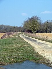
Français : A la limite entre les communes de Laimont et Villers-aux-Vents (55 Meuse) l'ancienne voie romaine Reims Toul à l'endroit où elle rejoint l'actuelle route départementale D75. |
| Dät | 1/4/2013 à 10:43 |
| Fon | Vobot okik |
| Lautan | Utilisateur:Djampa - User:Djampa |
| Camera location | | View this and other nearby images on: OpenStreetMap |
|---|
_voie_romaine_Reims_Toul.jpg¶ms=048.846248_N_0005.012122_E_globe:Earth_type:camera_Heading:WNW_&language=vo)
Dälastad
I, the copyright holder of this work, hereby publish it under the following licenses:

|
Däl pagevon ad kopiedön, seagivön e/u votükön dokümi at ma Dälazöt ad Dokümam Libik: GNU, Fomam: 1.2 u nulikum fa el Free Software Foundation (Stitod: Nünömaprograms libik); nen diläds nevotükovik, nen vödems tegapada balid, e leigo nen vödems tegapada lätik. Kopied dälazöta pekeninon in diläd: Dälazöt ad Dokümam Libik: GNU panemöl. |
This file is licensed under the Creative Commons Attribution-Share Alike 4.0 International, 3.0 Unported, 2.5 Generic, 2.0 Generic and 1.0 Generic license.
- Binol libik:
- to share – to copy, distribute and transmit the work
- to remix – to adapt the work
- Under the following conditions:
- attribution – You must give appropriate credit, provide a link to the license, and indicate if changes were made. You may do so in any reasonable manner, but not in any way that suggests the licensor endorses you or your use.
- share alike – If you remix, transform, or build upon the material, you must distribute your contributions under the same or compatible license as the original.
You may select the license of your choice.
Jenotem ragiva
Välolös däti/timi ad logön ragivi soäsä äbinon ün tim at.
| Dät/Tim | Magodil | Mafots | Geban | Küpet | |
|---|---|---|---|---|---|
| anuik | 14:21, 2013 tobul 15id | | 3,000 × 4,000 (1.73 MB) | Djampa | lumière |
| 13:15, 2013 prilul 4id |  | 3,000 × 4,000 (1.55 MB) | Rotatebot | Bot: Image rotated by 270° (EXIF-Orientation set from 6 to 1, rotated 0°) | |
| 12:18, 2013 prilul 4id |  | 4,000 × 3,000 (1.55 MB) | Djampa | {{Information |Description ={{fr|1=Laimont Villers-aux-Vents (55 Meuse) voie romaine Reims Toul}} |Source =Own work - Travail personnel |Author =Utilisateur:Djampa - User:Djampa |Date ... |
Yüms
Pads nonik peyümons ad ragiv at.
Ragivigeb Valöpik
The following other wikis use this file:
- Geb su ast.wikipedia.org
- Geb su ca.wikipedia.org
- Geb su ceb.wikipedia.org
- Geb su ce.wikipedia.org
- Geb su de.wikipedia.org
- Geb su diq.wikipedia.org
- Geb su es.wikipedia.org
- Geb su eu.wikipedia.org
- Geb su fi.wikipedia.org
- Geb su fr.wikipedia.org
- Geb su hu.wikipedia.org
- Geb su it.wikipedia.org
- Geb su ku.wikipedia.org
- Geb su la.wikipedia.org
- Geb su ms.wikipedia.org
- Geb su nl.wikipedia.org
- Geb su no.wikipedia.org
- Geb su pl.wikipedia.org
- Geb su pt.wikipedia.org
- Geb su ro.wikipedia.org
- Geb su sk.wikipedia.org
- Geb su sv.wikipedia.org
- Geb su tt.wikipedia.org
- Geb su uk.wikipedia.org
- Geb su uz.wikipedia.org
- Geb su vec.wikipedia.org
View more global usage of this file.
_voie_romaine_Reims_Toul.jpg)
_voie_romaine_Reims_Toul.jpg)