
Ragiv:LocationLiechtenstein.png
Gretot gudikum no pagebidon.
LocationLiechtenstein.png (250 × 115 pixel, ragivagret: 6 KB, pated MIME: image/png)
Plän brefik
| Bepenam |
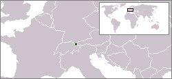
English: Location map for Liechtenstein.
Deutsch: Karte zur Lage von Liechtenstein. |
|||
| Dät | ||||
| Fon | Originally created for English Wikipedia by Vardion. | |||
| Lautan | Vardion | |||
| Other versions |
|


Dälastad
| |
This work has been released into the public domain by its author, Vardion, at the Linglänapük Vükiped project. This applies worldwide. In case this is not legally possible: |
| Annotations | This image is annotated: View the annotations at Commons |
Jenotem ragiva
Välolös däti/timi ad logön ragivi soäsä äbinon ün tim at.
| Dät/Tim | Magodil | Mafots | Geban | Küpet | |
|---|---|---|---|---|---|
| anuik | 05:59, 2004 dekul 16id | | 250 × 115 (6 KB) | EugeneZelenko | Location map for the Liechtenstein.<br/>Originally created for English Wikipedia by Vardion.<br/>{{PD}}<br/>Category:Country locator maps |
| 15:11, 2004 dekul 12id |  | 250 × 115 (6 KB) | SpeedyGonsales | Location Liechtenstein |
Yüms
Pads sököl payümons ko pad at:
Ragivigeb Valöpik
The following other wikis use this file:
- Geb su als.wikipedia.org
- Geb su arc.wikipedia.org
- Geb su av.wikipedia.org
- Geb su bg.wikipedia.org
- Geb su bpy.wikipedia.org
- Geb su br.wikipedia.org
- Geb su ceb.wikipedia.org
- Geb su ckb.wikipedia.org
- Geb su cv.wikipedia.org
- Geb su de.wikipedia.org
- Geb su de.wikibooks.org
- Geb su de.wikinews.org
- Geb su de.wiktionary.org
- Geb su dsb.wikipedia.org
- Geb su el.wiktionary.org
- Geb su en.wikipedia.org
- Geb su en.wikivoyage.org
- Geb su en.wiktionary.org
- Geb su eo.wikipedia.org
- Geb su eo.wiktionary.org
- Geb su eu.wiktionary.org
- Geb su fa.wikipedia.org
- Geb su fiu-vro.wikipedia.org
- Geb su fr.wikipedia.org
- Geb su fr.wikinews.org
- Geb su fy.wikipedia.org
- Geb su gu.wikipedia.org
- Geb su he.wikivoyage.org
- Geb su hif.wikipedia.org
- Geb su ht.wikipedia.org
- Geb su ia.wikipedia.org
- Geb su id.wikipedia.org
- Geb su incubator.wikimedia.org
- Geb su it.wikivoyage.org
- Geb su ja.wikipedia.org
- Geb su jv.wikipedia.org
- Geb su ka.wiktionary.org
View more global usage of this file.