
Ragiv:LocationMauritania.png
Gretot gudikum no pagebidon.
LocationMauritania.png (250 × 115 pixel, ragivagret: 6 KB, pated MIME: image/png)
Plän brefik
| Bepenam | ||||
| Dät | ||||
| Fon | Originally created for English Wikipedia by Vardion. | |||
| Lautan | Vardion | |||
| Däl (Reusing this file) |
|
|||
| Other versions |
|


Jenotem ragiva
Välolös däti/timi ad logön ragivi soäsä äbinon ün tim at.
| Dät/Tim | Magodil | Mafots | Geban | Küpet | |
|---|---|---|---|---|---|
| anuik | 14:29, 2007 dekul 4id | | 250 × 115 (6 KB) | Gandal el gris | Reverted to version as of 07:01, 19 November 2007 |
| 11:29, 2007 dekul 4id |  | 250 × 115 (5 KB) | Tetouancity | Reverted to version as of 15:01, 14 November 2007 | |
| 07:01, 2007 novul 19id |  | 250 × 115 (6 KB) | Gandal el gris | ||
| 15:01, 2007 novul 14id |  | 250 × 115 (5 KB) | Vispec | Reverted to version as of 12:31, 11 November 2007 | |
| 14:34, 2007 novul 12id |  | 250 × 115 (6 KB) | CHV | Reverted to version as of 18:22, 12 December 2004 | |
| 12:31, 2007 novul 11id |  | 250 × 115 (5 KB) | Vispec | ||
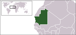
| 18:22, 2004 dekul 12id |  | 250 × 115 (6 KB) | EugeneZelenko | Location map for the Mauritania.<br/>Originally created for English Wikipedia by Vardion.<br/>{{PD}}<br/>Category:Country locator maps |
Yüms
Pads sököl payümons ko pad at:
Ragivigeb Valöpik
The following other wikis use this file:
- Geb su arc.wikipedia.org
- Geb su ar.wikinews.org
- Geb su az.wiktionary.org
- Geb su bg.wikipedia.org
- Geb su bm.wikipedia.org
- Geb su bpy.wikipedia.org
- Geb su br.wikipedia.org
- Geb su bs.wikipedia.org
- Geb su ca.wikinews.org
- Geb su de.wikinews.org
- Geb su de.wiktionary.org
- Geb su en.wikipedia.org
- Geb su en.wikinews.org
- Geb su en.wikivoyage.org
- Geb su en.wiktionary.org
- Geb su es.wikipedia.org
- Geb su es.wikinews.org
- Geb su fr.wikipedia.org
- Geb su fr.wikinews.org
- Geb su he.wikivoyage.org
- Geb su hr.wiktionary.org
View more global usage of this file.