
Ragiv:LocationSaintLucia.png
Gretot gudikum no pagebidon.
LocationSaintLucia.png (250 × 115 pixel, ragivagret: 3 KB, pated MIME: image/png)
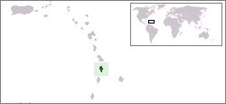
Location map for the Saint Lucia.
Originally created for English Wikipedia by Vardion.
| |
This work has been released into the public domain by its author, Vardion, at the Linglänapük Vükiped project. This applies worldwide. In case this is not legally possible: |

|
This locator map image could be re-created using vector graphics as an SVG file. This has several advantages; see Commons:Media for cleanup for more information. If an SVG form of this image is available, please upload it and afterwards replace this template with
{{vector version available|new image name}}.
It is recommended to name the SVG file “LocationSaintLucia.svg”—then the template Vector version available (or Vva) does not need the new image name parameter. |
Jenotem ragiva
Välolös däti/timi ad logön ragivi soäsä äbinon ün tim at.
| Dät/Tim | Magodil | Mafots | Geban | Küpet | |
|---|---|---|---|---|---|
| anuik | 18:28, 2008 yanul 16id | | 250 × 115 (3 KB) | Mahahahaneapneap | pngcrushed |
| 03:03, 2004 dekul 20id |  | 250 × 115 (5 KB) | EugeneZelenko | Location map for the Saint Lucia.<br/>Originally created for English Wikipedia by Vardion.<br/>{{PD}}<br/>Category:Country locator maps |
Yüms
Pads sököl payümons ko pad at:
Ragivigeb Valöpik
The following other wikis use this file:
- Geb su ar.wikipedia.org
- Geb su az.wiktionary.org
- Geb su ba.wikipedia.org
- Geb su be-tarask.wikipedia.org
- Geb su be.wikipedia.org
- Geb su bg.wikipedia.org
- Geb su bn.wikipedia.org
- Geb su bo.wikipedia.org
- Geb su bpy.wikipedia.org
- Geb su bs.wikipedia.org
- Geb su ca.wikipedia.org
- Geb su ceb.wikipedia.org
- Geb su ckb.wikipedia.org
- Geb su da.wikipedia.org
- Geb su de.wikivoyage.org
- Geb su de.wiktionary.org
- Geb su el.wiktionary.org
- Geb su en.wikipedia.org
- Geb su en.wikivoyage.org
- Geb su eo.wikipedia.org
- Geb su es.wikipedia.org
- Geb su es.wikinews.org
- Geb su ext.wikipedia.org
- Geb su fa.wikipedia.org
- Geb su fiu-vro.wikipedia.org
- Geb su fo.wikipedia.org
- Geb su frp.wikipedia.org
- Geb su fr.wikipedia.org
- Geb su fy.wikipedia.org
- Geb su gv.wikipedia.org
- Geb su he.wikivoyage.org
- Geb su hif.wikipedia.org
- Geb su hr.wikipedia.org
- Geb su ht.wikipedia.org
- Geb su hu.wikipedia.org
View more global usage of this file.