
Ragiv:MenenLocation.png
Gretot gudikum no pagebidon.
MenenLocation.png (270 × 203 pixel, ragivagret: 5 KB, pated MIME: image/png)

|
File:Menen West-Flanders Belgium Map.svg is a vector version of this file. It should be used in place of this PNG file when not inferior.
File:MenenLocation.png → File:Menen West-Flanders Belgium Map.svg
For more information, see Help:SVG. |
 |
Plän brefik
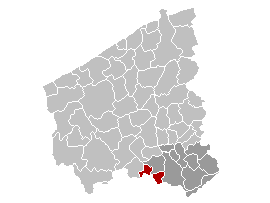
en: Map of the province West-Flanders, showing Menen municipality in red, and Kortrijk arrondissement in dark
fr: Carte indiquant la localisation de la commune de Menin (en rouge) dans la province de Flandre occidentale, avec l'arrondissement de Courtrai en gris foncé
nl: Kaart van de provincie West-Vlaanderen met de gemeente Menen in het rood en het arrondissement Kortrijk in het donkergrijs.
Dälastad
| I, the copyright holder of this work, release this work into the public domain. This applies worldwide. In some countries this may not be legally possible; if so: I grant anyone the right to use this work for any purpose, without any conditions, unless such conditions are required by law. |
Jenotem ragiva
Välolös däti/timi ad logön ragivi soäsä äbinon ün tim at.
| Dät/Tim | Magodil | Mafots | Geban | Küpet | |
|---|---|---|---|---|---|
| anuik | 18:17, 2006 yanul 11id | | 270 × 203 (5 KB) | Wester |
Yüms
Pads nonik peyümons ad ragiv at.
Ragivigeb Valöpik
The following other wikis use this file:
- Geb su eo.wikipedia.org
- Geb su fa.wikipedia.org
- Geb su fy.wikipedia.org
- Geb su it.wikipedia.org
- Geb su li.wikipedia.org
- Geb su nn.wikipedia.org
- Geb su pt.wikipedia.org
- Geb su ro.wikipedia.org
- Geb su sk.wikipedia.org
- Geb su stq.wikipedia.org
- Geb su sv.wikipedia.org
- Geb su vls.wikipedia.org