
Ragiv:Mons, Hérault 01.jpg

Size of this preview: 800 × 500 pixels. Other resolutions: 320 × 200 pixels • 640 × 400 pixels • 1,024 × 640 pixels • 1,280 × 800 pixels • 2,560 × 1,600 pixels • 6,016 × 3,760 pixels.
Ragiv rigik (6,016 × 3,760 pixel, ragivagret: 18.25 MB, pated MIME: image/jpeg)
Plän brefik
| Bepenam |
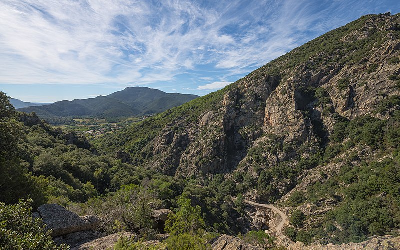
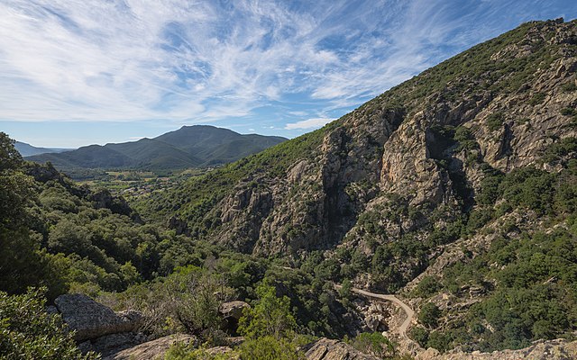
Français : L'extrémité sud des Gorges d'Héric, en haut à droite le Pas du Cabalet (543m), en contrebas au premier plan le Ruisseau d'Héric, dans le fond à gauche la vallée du Jaur et derrière cette dernière le Mont Naudech (753m). Mons, Hérault, France. Parc naturel régional du Haut-Languedoc. English: The Southern end of the Gorges d'Héric, at above on the right the Pas du Cabalet (543m), below in the foreground the Ruisseau d'Héric, in the background in the left the Jaur Valley and behind it the Mont Naudech (753m). Mons, Hérault, France. Haut-Languedoc Regional Natural Park. |
| Dät | Taken on 1 tobul 2013, 12:10:06 |
| Fon | Vobot okik |
| Lautan | Christian Ferrer |
| Däl (Reusing this file) |
I, the copyright holder of this work, hereby publish it under the following license: This file is licensed under the Creative Commons Attribution-Share Alike 3.0 Unported license.
|
| Camera location | | View this and other nearby images on: OpenStreetMap |
|---|
|

| Annotations | This image is annotated: View the annotations at Commons |

|
This image has been assessed under the valued image criteria and is considered the most valued image on Commons within the scope: Southern end of the Gorges d'Héric. View from Northeast in 2013.. You can see its nomination here. |
Jenotem ragiva
Välolös däti/timi ad logön ragivi soäsä äbinon ün tim at.
| Dät/Tim | Magodil | Mafots | Geban | Küpet | |
|---|---|---|---|---|---|
| anuik | 05:50, 2013 tobul 12id | | 6,016 × 3,760 (18.25 MB) | Christian Ferrer | User created page with UploadWizard |
Yüms
Pads sököl payümons ko pad at:
Ragivigeb Valöpik
The following other wikis use this file:
- Geb su ca.wikipedia.org
- Geb su ceb.wikipedia.org
- Geb su de.wikipedia.org
- Geb su en.wikipedia.org
- Geb su en.wikivoyage.org
- Geb su es.wikipedia.org
- Geb su eu.wikipedia.org
- Geb su fr.wikipedia.org
- Geb su it.wikipedia.org
- Geb su kk.wikipedia.org
- Geb su lb.wikipedia.org
- Geb su mg.wikipedia.org
- Geb su ms.wikipedia.org
- Geb su nl.wikipedia.org
- Geb su oc.wikipedia.org
- Geb su pl.wikipedia.org
- Geb su pms.wikipedia.org
- Geb su pt.wikipedia.org
- Geb su ro.wikipedia.org
- Geb su sv.wikipedia.org
- Geb su uk.wikipedia.org
- Geb su vi.wikipedia.org
- Geb su war.wikipedia.org
- Geb su www.wikidata.org