
Ragiv:Occitania blanck map.PNG
Gretot gudikum no pagebidon.
Occitania_blanck_map.PNG (573 × 397 pixel, ragivagret: 10 KB, pated MIME: image/png)

|
This linguistic map image could be re-created using vector graphics as an SVG file. This has several advantages; see Commons:Media for cleanup for more information. If an SVG form of this image is available, please upload it and afterwards replace this template with
{{vector version available|new image name}}.
It is recommended to name the SVG file “Occitania blanck map.svg”—then the template Vector version available (or Vva) does not need the new image name parameter. |
Plän brefik
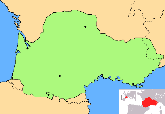
| Bepenam | Correct map of Occitania, with geographic context and remarking of the country borders |
| Dät | |
| Fon | Vobot okik |
| Lautan | Norrin strange |
| Other versions | Derivative works of this file: Occitania aranes map.png |
I, the copyright holder of this work, hereby publish it under the following licenses:

|
Däl pagevon ad kopiedön, seagivön e/u votükön dokümi at ma Dälazöt ad Dokümam Libik: GNU, Fomam: 1.2 u nulikum fa el Free Software Foundation (Stitod: Nünömaprograms libik); nen diläds nevotükovik, nen vödems tegapada balid, e leigo nen vödems tegapada lätik. Kopied dälazöta pekeninon in diläd: Dälazöt ad Dokümam Libik: GNU panemöl. |
| This file is licensed under the Creative Commons Attribution-Share Alike 3.0 Unported license. | ||
| ||
| This licensing tag was added to this file as part of the GFDL licensing update. |
You may select the license of your choice.
Jenotem ragiva
Välolös däti/timi ad logön ragivi soäsä äbinon ün tim at.
| Dät/Tim | Magodil | Mafots | Geban | Küpet | |
|---|---|---|---|---|---|
| anuik | 18:30, 2023 yunul 27id | | 573 × 397 (10 KB) | Jfblanc | Improved boundaries |
| 22:10, 2020 setul 4id |  | 573 × 397 (4 KB) | TSamuel | Minimized colors to 7 to recompress further | |
| 22:08, 2020 setul 4id |  | 573 × 397 (5 KB) | TSamuel | Losslessly recompressed | |
| 16:32, 2009 febul 17id |  | 573 × 397 (12 KB) | Tripallokavipasek | ||
| 15:21, 2007 yulul 14id |  | 573 × 397 (11 KB) | Norrin strange | {{Information |Description=Correct map of Occitania |Source=self-made |Date=14-07-07 |Author= Norrin strange }} {{GFDL-Self}} |
Yüms
Pads sököl payümons ko pad at:
Ragivigeb Valöpik
The following other wikis use this file:
- Geb su ace.wikipedia.org
- Geb su ady.wikipedia.org
- Geb su am.wikipedia.org
- Geb su an.wikipedia.org
- Geb su ar.wikipedia.org
- Geb su be.wikipedia.org
- Geb su br.wikipedia.org
- Geb su ca.wikipedia.org
- Geb su ce.wikipedia.org
- Geb su ckb.wikipedia.org
- Geb su cs.wikipedia.org
- Geb su cv.wikipedia.org
- Geb su cy.wikipedia.org
- Geb su da.wikipedia.org
- Geb su diq.wikipedia.org
- Geb su en.wiktionary.org
- Geb su eo.wikipedia.org
- Geb su eo.wikinews.org
- Geb su es.wikipedia.org
- Geb su et.wikipedia.org
- Geb su eu.wikipedia.org
- Geb su fa.wikipedia.org
- Geb su fi.wikipedia.org
- Geb su fr.wikipedia.org
- Geb su fr.wiktionary.org
- Geb su fur.wikipedia.org
- Geb su gd.wikipedia.org
- Geb su gl.wikipedia.org
- Geb su gv.wikipedia.org
- Geb su hr.wikipedia.org
- Geb su hr.wiktionary.org
- Geb su hsb.wikipedia.org
- Geb su hu.wikipedia.org
- Geb su hy.wikipedia.org
- Geb su id.wikipedia.org
- Geb su ilo.wikipedia.org
- Geb su io.wikipedia.org
View more global usage of this file.