
Ragiv:Pula Aerial View.jpg

Size of this preview: 800 × 488 pixels. Other resolutions: 320 × 195 pixels • 640 × 390 pixels • 1,024 × 625 pixels • 1,495 × 912 pixels.
Ragiv rigik (1,495 × 912 pixel, ragivagret: 1.01 MB, pated MIME: image/jpeg)

|
This image has been assessed under the valued image criteria and is considered the most valued image on Commons within the scope: Pula, Croatia. You can see its nomination here. |
| Bepenam |
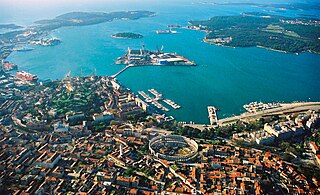
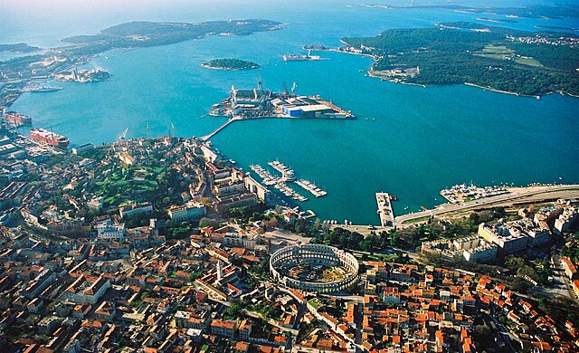
English: Aerial view of Pula, Croatia. The most notable object, on the bottom of the photo, is the Arena Amphiteathre. Left of it is the hill around which lies the Old Town. The wedge-shaped island in the middle of the bay is Uljanik, part of the shipyard. On the far top right the Brijuni islands (a National Park) can be seen.
Русский: Вид с высоты птичьего полета на Пулу (Хорватия). Самый примечательный объект, расположенный в нижней части фотографии, это амфитеатр Пулы. Слева от него находится холм, вокруг которого раскинулся Старый город. Клиновидный остров посреди бухты - это Uljanik, часть верфи. В дальнем правом верхнем углу видны острова Бриони (национальный парк). |
||||||||
| Dät | 02:57, 19 ago 2007 (dati Exif) | ||||||||
| Fon |
self-made, better version than |
||||||||
| Lautan | Orlovic | ||||||||
| Däl (Reusing this file) |
|
| Camera location | | View this and other nearby images on: OpenStreetMap |
|---|
Notes
- I uploaded it also on Panoramio, but only after doing it on commons --Orlovic 21:40, 5 February 2007 (UTC)

|
Däl pagevon ad kopiedön, seagivön e/u votükön dokümi at ma Dälazöt ad Dokümam Libik: GNU, Fomam: 1.2 u nulikum fa el Free Software Foundation (Stitod: Nünömaprograms libik); nen diläds nevotükovik, nen vödems tegapada balid, e leigo nen vödems tegapada lätik. Kopied dälazöta pekeninon in diläd: Dälazöt ad Dokümam Libik: GNU panemöl. |
| This file is licensed under the Creative Commons Attribution-Share Alike 3.0 Unported license. | ||
| ||
| This licensing tag was added to this file as part of the GFDL licensing update. |
| Annotations | This image is annotated: View the annotations at Commons |
Jenotem ragiva
Välolös däti/timi ad logön ragivi soäsä äbinon ün tim at.
| Dät/Tim | Magodil | Mafots | Geban | Küpet | |
|---|---|---|---|---|---|
| anuik | 01:06, 2007 gustul 19id | | 1,495 × 912 (1.01 MB) | Orlovic | {{Information |Description=Aerial view of Pula, Croatia |Source= My friend gave me the photo to publish under GFDL, better version than 50px |Date= |Author= Darko D. |permission={{GFDL}} }} == Notes == *I uploaded it also on [htt |
| 01:01, 2007 gustul 19id |  | 1,495 × 1,000 (1.68 MB) | Orlovic | {{Information |Description=Aerial view of Pula, Croatia |Source= My friend gave me the photo to publish under GFDL, better version than 50px |Date= |Author= Darko D. |permission={{GFDL}} }} == Notes == *I uploaded it also on [htt |
Yüms
Pads sököl payümons ko pad at:
Ragivigeb Valöpik
The following other wikis use this file:
- Geb su af.wikipedia.org
- Geb su ar.wikipedia.org
- Geb su arz.wikipedia.org
- Geb su avk.wikipedia.org
- Geb su az.wikipedia.org
- Geb su ba.wikipedia.org
- Geb su be-tarask.wikipedia.org
- Geb su be.wikipedia.org
- Geb su bg.wikipedia.org
- Geb su bs.wikipedia.org
- Geb su ca.wikipedia.org
- Geb su ceb.wikipedia.org
- Geb su cs.wikipedia.org
- Geb su cy.wikipedia.org
- Geb su da.wikipedia.org
- Geb su de.wikipedia.org
- Geb su de.wikivoyage.org
- Geb su el.wikipedia.org
- Geb su en.wikipedia.org
- Geb su en.wikivoyage.org
- Geb su eo.wikipedia.org
View more global usage of this file.