
Ragiv:Richterswil - Horgen - Au - Albis-Felsenegg-Uetliberg - Zürich - Lägern - Zürichsee - Pfannenstiel - Feusisberg - Etzel 2010-10-21 15-51-22.JPG

Size of this preview: 800 × 531 pixels. Other resolutions: 320 × 213 pixels • 640 × 425 pixels • 1,024 × 680 pixels • 1,280 × 850 pixels • 2,560 × 1,700 pixels • 4,288 × 2,848 pixels.
Ragiv rigik (4,288 × 2,848 pixel, ragivagret: 2.77 MB, pated MIME: image/jpeg)
Plän brefik
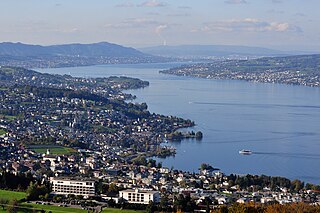
| Bepenam | View from the Etzel mountain in Switzerland towards Etzel Kulm – focus on Richterswil : (from the left side) Richterswil and Horgen on Zürichsee lakeshore, Au peninsula, Albis chain with Felsenegg and Uetliberg, Zürich in the far background, Pfannenstiel (partially) to the right. Zürichsee-Schiffahrtsgesellschaft (ZSG) MS Säntis towards Rapperswil docking at Richterswil harbour, ZSG MS Panta Rhei is sailing towards Richterswil. |
| Dät | |
| Fon | Vobot okik |
| Lautan | Roland zh |
| Other versions |
|


| Camera location | | View this and other nearby images on: OpenStreetMap |
|---|
Dälastad
I, the copyright holder of this work, hereby publish it under the following license:
This file is licensed under the Creative Commons Attribution-Share Alike 3.0 Unported license.
- Binol libik:
- to share – to copy, distribute and transmit the work
- to remix – to adapt the work
- Under the following conditions:
- attribution – You must give appropriate credit, provide a link to the license, and indicate if changes were made. You may do so in any reasonable manner, but not in any way that suggests the licensor endorses you or your use.
- share alike – If you remix, transform, or build upon the material, you must distribute your contributions under the same or compatible license as the original.
Jenotem ragiva
Välolös däti/timi ad logön ragivi soäsä äbinon ün tim at.
| Dät/Tim | Magodil | Mafots | Geban | Küpet | |
|---|---|---|---|---|---|
| anuik | 18:40, 2010 tobul 25id | | 4,288 × 2,848 (2.77 MB) | Roland zh | == {{int:filedesc}} == {{Information |Description= View from the ''Etzel'' mountain in Switzerland towards Etzel ''Kulm'' – focus on Richterswil : (from the left side) [[:Category:Richterswil|Ric |
Yüms
Pads sököl payümons ko pad at:
Ragivigeb Valöpik
The following other wikis use this file:
- Geb su als.wikipedia.org
- Geb su ar.wikipedia.org
- Geb su ca.wikipedia.org
- Geb su ceb.wikipedia.org
- Geb su da.wikipedia.org
- Geb su de.wikipedia.org
- Geb su es.wikipedia.org
- Geb su eu.wikipedia.org
- Geb su fi.wikipedia.org
- Geb su ga.wikipedia.org
- Geb su it.wikipedia.org
- Geb su kk.wikipedia.org
- Geb su ku.wikipedia.org
- Geb su lmo.wikipedia.org
- Geb su pl.wikipedia.org
- Geb su ru.wikipedia.org
- Geb su uk.wikipedia.org
- Geb su uz.wikipedia.org
- Geb su vec.wikipedia.org
- Geb su www.wikidata.org
- Geb su zh.wikipedia.org