
Ragiv:Thur Thann.jpg

Size of this preview: 800 × 600 pixels. Other resolutions: 320 × 240 pixels • 640 × 480 pixels • 1,024 × 768 pixels • 1,200 × 900 pixels.
Ragiv rigik (1,200 × 900 pixel, ragivagret: 220 KB, pated MIME: image/jpeg)
Plän brefik
| Bepenam |
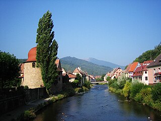
Deutsch: Die Thur fließt durch Thann. |
| Dät |
4 setul 2005 (photo) |
| Fon | aufgenommen von Runghold |
| Lautan | Runghold at Deutänapük Vükiped |
| Camera location | | View this and other nearby images on: OpenStreetMap |
|---|
Dälastad
Runghold from de.wikipedia.org, the copyright holder of this work, hereby publishes it under the following license:

|
Däl pagevon ad kopiedön, seagivön e/u votükön dokümi at ma Dälazöt ad Dokümam Libik: GNU, Fomam: 1.2 u nulikum fa el Free Software Foundation (Stitod: Nünömaprograms libik); nen diläds nevotükovik, nen vödems tegapada balid, e leigo nen vödems tegapada lätik. Kopied dälazöta pekeninon in diläd: Dälazöt ad Dokümam Libik: GNU panemöl. |
| This file is licensed under the Creative Commons Attribution-Share Alike 3.0 Unported license. | ||
| Attribution: Runghold | ||
| ||
| This licensing tag was added to this file as part of the GFDL licensing update. |
Original upload log
The original description page was here. All following user names refer to de.wikipedia.
- 2005-09-05 19:59 Runghold 1200×900× (225420 bytes) Die Thur fließt durch Thann, aufgenommen von [[Benutzer:Runghold|Runghold]] am 4. September 2005
Jenotem ragiva
Välolös däti/timi ad logön ragivi soäsä äbinon ün tim at.
| Dät/Tim | Magodil | Mafots | Geban | Küpet | |
|---|---|---|---|---|---|
| anuik | 22:53, 2005 setul 11id | | 1,200 × 900 (220 KB) | Jef-Infojef | == Beschreibung, Quelle und Lizenz == Die Thur fließt durch Thann, aufgenommen von Runghold am 4. September 2005 |
Yüms
Pads sököl payümons ko pad at:
Ragivigeb Valöpik
The following other wikis use this file:
- Geb su als.wikipedia.org
- Geb su an.wikipedia.org
- Geb su ar.wikipedia.org
- Geb su arz.wikipedia.org
- Geb su be.wikipedia.org
- Geb su ca.wikipedia.org
- Geb su ce.wikipedia.org
- Geb su da.wikipedia.org
- Geb su de.wikipedia.org
- Geb su de.wikivoyage.org
- Geb su diq.wikipedia.org
- Geb su el.wikipedia.org
- Geb su en.wikipedia.org
- Geb su eo.wikipedia.org
- Geb su es.wikipedia.org
- Geb su et.wikipedia.org
- Geb su eu.wikipedia.org
- Geb su fr.wikipedia.org
- Geb su fr.wikivoyage.org
- Geb su hu.wikipedia.org
- Geb su it.wikipedia.org
- Geb su it.wikivoyage.org
- Geb su la.wikipedia.org
- Geb su lb.wikipedia.org
- Geb su lld.wikipedia.org
- Geb su ms.wikipedia.org
- Geb su nl.wikipedia.org
- Geb su nn.wikipedia.org
- Geb su no.wikipedia.org
- Geb su oc.wikipedia.org
- Geb su pfl.wikipedia.org
View more global usage of this file.