
Ragiv:United Nations Members (green–grey scheme).svg

Size of this PNG preview of this SVG file: 800 × 410 pixels. Other resolutions: 320 × 164 pixels • 640 × 328 pixels • 1,024 × 525 pixels • 1,280 × 656 pixels • 2,560 × 1,312 pixels • 1,104 × 566 pixels.
Ragiv rigik (ragiv in fomät: SVG, magodaziöbs 1,104 × 566, gretot: 1.44 MB)
.svg)
Plän brefik
| Bepenam |
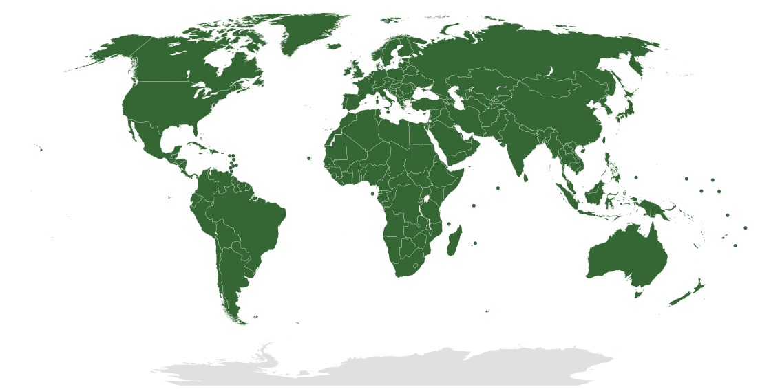
Deutsch: Karte der Mitgliedsstaaten der Vereinten Nationen. Keine Mitglieder sind: Vatikanstadt, Palästinensische Autonomiegebiete, Westsahara. Gebiete von Staaten, die nicht von den VN anerkannt werden, werden nicht ausgeschlossen, da sie ein Teil eines VN-Mitgliedsstaates sind, darunter Kosovo, Abchasien, Südossetien, Puerto Rico, Somaliland, Republik China (Taiwan) usw.
English: Map of UN member states. Non-members shown: Vatican City, Palestinian territories, Western Sahara. Territories of states not recognized by the UN are not included due to the fact that they appear to be part of some UN member state on UN's maps, including Kosovo, Abkhazia, South Ossetia, Somaliland, Republic of China (Taiwan), etc.
For further information see The World Today. Archived from the original on 19 March 2015. Retrieved on 18 June 2009. "The designations employed and the presentation of material on this map do not imply the expression of any opinion whatsoever on the part of the Secretariat of the United Nations concerning the legal status of any country" |
| Dät | |
| Fon | Modified from File:United Nations Members.svg by Lateiner (created 16 February 2008), itself modified from File:BlankMap-World-Microstates.svg, source from UN |
| Lautan | Rob984 |
| Other versions | United Nations Members.svg and United Nations Members.PNG |
Dälastad
I, the copyright holder of this work, hereby publish it under the following license:
This file is licensed under the Creative Commons Attribution-Share Alike 4.0 International license.
- Binol libik:
- to share – to copy, distribute and transmit the work
- to remix – to adapt the work
- Under the following conditions:
- attribution – You must give appropriate credit, provide a link to the license, and indicate if changes were made. You may do so in any reasonable manner, but not in any way that suggests the licensor endorses you or your use.
- share alike – If you remix, transform, or build upon the material, you must distribute your contributions under the same or compatible license as the original.
Jenotem ragiva
Välolös däti/timi ad logön ragivi soäsä äbinon ün tim at.
| Dät/Tim | Magodil | Mafots | Geban | Küpet | |
|---|---|---|---|---|---|
| anuik | 09:42, 2019 setul 1id | | 1,104 × 566 (1.44 MB) | Wadaad | Morocco-SADR |
| 22:59, 2018 tobul 17id |  | 1,104 × 566 (1.44 MB) | Ratherous | Better resolution and only keep dots for independent members for less confusion | |
| 10:18, 2016 yulul 29id |  | 940 × 477 (1.45 MB) | Rob984 | Correcting omission of Mayotte | |
| 17:02, 2016 yulul 26id |  | 940 × 477 (1.45 MB) | Rob984 | User created page with UploadWizard |
Yüms
Pads nonik peyümons ad ragiv at.
.svg)