
Ragiv:Aerial view of Hadleigh centre in the snow - geograph.org.uk - 1563668.jpg
Gretot gudikum no pagebidon.
Aerial_view_of_Hadleigh_centre_in_the_snow_-_geograph.org.uk_-_1563668.jpg (640 × 503 pixel, ragivagret: 301 KB, pated MIME: image/jpeg)
Plän brefik
| Bepenam |
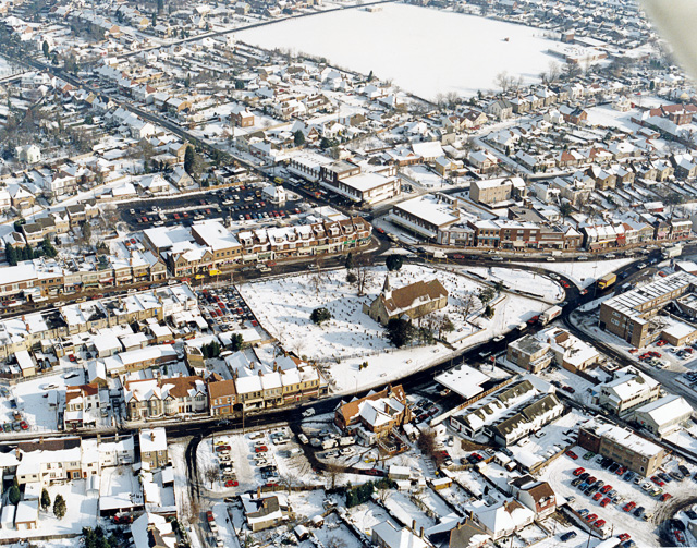
English: Aerial view of Hadleigh centre in the snow The church in the middle of the picture is St James-the-less. The large building below left of this is The Castle pub. Most of the buildings lining the major roads here are shops. The large white rectangle at the top is a school playing field, with the school to the right. |
| Dät | |
| Fon | From geograph.org.uk |
| Lautan | Edward Clack |
| Attribution (required by the license) | Edward Clack / Aerial view of Hadleigh centre in the snow / |
| Camera location | | View this and other nearby images on: OpenStreetMap |
|---|
_heading:67.00&language=vo)
| Object location | | View this and other nearby images on: OpenStreetMap |
|---|
_heading:67.00&language=vo)
Dälastad

|
This image was taken from the Geograph project collection. See this photograph's page on the Geograph website for the photographer's contact details. The copyright on this image is owned by Edward Clack and is licensed for reuse under the Creative Commons Attribution-ShareAlike 2.0 license.
|
This file is licensed under the Creative Commons Attribution-Share Alike 2.0 Generic license.
Attribution: Edward Clack
- Binol libik:
- to share – to copy, distribute and transmit the work
- to remix – to adapt the work
- Under the following conditions:
- attribution – You must give appropriate credit, provide a link to the license, and indicate if changes were made. You may do so in any reasonable manner, but not in any way that suggests the licensor endorses you or your use.
- share alike – If you remix, transform, or build upon the material, you must distribute your contributions under the same or compatible license as the original.
Jenotem ragiva
Välolös däti/timi ad logön ragivi soäsä äbinon ün tim at.
| Dät/Tim | Magodil | Mafots | Geban | Küpet | |
|---|---|---|---|---|---|
| anuik | 16:01, 2011 mäzul 3id | | 640 × 503 (301 KB) | GeographBot | == {{int:filedesc}} == {{Information |description={{en|1=Aerial view of Hadleigh centre in the snow The church in the middle of the picture is St James-the-less. The large building below left of this is The Castle pub. Most of the buildings lining the maj |
Yüms
Pads sököl payümons ko pad at:
Ragivigeb Valöpik
The following other wikis use this file:
- Geb su af.wikipedia.org
- Geb su azb.wikipedia.org
- Geb su ceb.wikipedia.org
- Geb su cy.wikipedia.org
- Geb su en.wikipedia.org
- Geb su fa.wikipedia.org
- Geb su fr.wikipedia.org
- Geb su ga.wikipedia.org
- Geb su it.wikipedia.org
- Geb su lld.wikipedia.org
- Geb su nl.wikipedia.org
- Geb su sv.wikipedia.org
- Geb su www.wikidata.org