
Ragiv:Aerial view of Moses Lake & Potholes Reservoir, Washington 01A.jpg

Size of this preview: 800 × 600 pixels. Other resolutions: 320 × 240 pixels • 640 × 480 pixels • 1,024 × 768 pixels • 1,280 × 960 pixels • 2,560 × 1,920 pixels • 3,264 × 2,448 pixels.
Ragiv rigik (3,264 × 2,448 pixel, ragivagret: 3.02 MB, pated MIME: image/jpeg)
Plän brefik
| Bepenam |
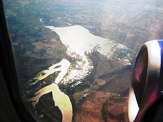
English: Aerial photo of Moses Lake & Potholes Reservoir, Washington, USA. Moses Lake is at lower left; Potholes Reservoir at center. The view is looking roughly southward. The road cutting across Moses Lake is Interstate 90. |
| Dät | |
| Fon | Photo by Joe Mabel |
| Lautan | Joe Mabel |
| Däl (Reusing this file) |
GFDL granted by photographer |
| Other versions | File:Aerial view of Moses Lake & Potholes Reservoir, Washington 01.jpg is raw. File:Aerial view of Moses Lake & Potholes Reservoir, Washington 01A.jpg is colormapped to enhance contrast. |
Dälastad
Joe Mabel, the copyright holder of this work, hereby publishes it under the following licenses:

|
Däl pagevon ad kopiedön, seagivön e/u votükön dokümi at ma Dälazöt ad Dokümam Libik: GNU, Fomam: 1.2 u nulikum fa el Free Software Foundation (Stitod: Nünömaprograms libik); nen diläds nevotükovik, nen vödems tegapada balid, e leigo nen vödems tegapada lätik. Kopied dälazöta pekeninon in diläd: Dälazöt ad Dokümam Libik: GNU panemöl. |
| This file is licensed under the Creative Commons Attribution-Share Alike 3.0 Unported license. | ||
| Attribution: Joe Mabel | ||
| ||
| This licensing tag was added to this file as part of the GFDL licensing update. |
You may select the license of your choice.
Jenotem ragiva
Välolös däti/timi ad logön ragivi soäsä äbinon ün tim at.
| Dät/Tim | Magodil | Mafots | Geban | Küpet | |
|---|---|---|---|---|---|
| anuik | 15:22, 2012 gustul 21id | | 3,264 × 2,448 (3.02 MB) | Jmabel | Equalized, then slightly darkened, probably a more useful version of this. |
| 02:57, 2009 mäzul 18id |  | 3,264 × 2,448 (1.71 MB) | Jmabel | ==Summary== {{Information |Description=Aerial photo of Moses Lake & Potholes Reservoir, Washington, USA. Moses Lake is at lower left; Potholes Reservoir at center. The view is looking roughly southward. The road cutting across Moses Lake is Interstate 90. |
Yüms
Pads sököl payümons ko pad at:
Ragivigeb Valöpik
The following other wikis use this file:
- Geb su ar.wikipedia.org
- Geb su arz.wikipedia.org
- Geb su azb.wikipedia.org
- Geb su bg.wikipedia.org
- Geb su ca.wikipedia.org
- Geb su ceb.wikipedia.org
- Geb su ce.wikipedia.org
- Geb su cs.wikipedia.org
- Geb su cy.wikipedia.org
- Geb su dag.wikipedia.org
- Geb su de.wikipedia.org
- Geb su en.wikipedia.org
- Geb su en.wikivoyage.org
- Geb su eo.wikipedia.org
- Geb su eu.wikipedia.org
- Geb su fa.wikipedia.org
- Geb su fr.wikipedia.org
- Geb su ht.wikipedia.org
- Geb su it.wikipedia.org
- Geb su ko.wikipedia.org
- Geb su lld.wikipedia.org
- Geb su no.wikipedia.org
- Geb su pl.wikipedia.org
- Geb su pt.wikipedia.org
- Geb su ru.wikipedia.org
- Geb su sr.wikipedia.org
- Geb su tr.wikipedia.org
- Geb su tt.wikipedia.org
- Geb su uk.wikipedia.org
- Geb su uz.wikipedia.org
- Geb su vi.wikipedia.org
- Geb su www.wikidata.org
- Geb su zh-min-nan.wikipedia.org
- Geb su zh.wikipedia.org