Jump to content

Ragiv:Map Bih entities lat.png

Page contents not supported in other languages.
Se Vükiped: sikloped libik

Ragiv rigik (1,103 × 1,044 pixel, ragivagret: 66 KB, pated MIME: image/png)

Ragiv at kömon de Wikimedia Commons e kanon pagebön fa proyegs votik. Bepenot su pad bepenota ragiva onik pajonon dono.

Plän brefik

Bepenam
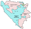
English: Map showing political division of Bosnia and Herzegovina: Federation of Bosnia and Herzegovina, Republika Srpska and Brčko District.

Bosanski: / Srpski: / Hrvatski: Mapa koja prikazuje političku podjelu Bosne i Hercegovine: Federaciju Bosne i Hercegovine, Republiku Srpsku i Distrikt Brčko.
Dät
Fon Vobot okik
Lautan PANONIAN
Other versions

[redakön]

Dälastad

I, the copyright holder of this work, hereby publish it under the following license:
Creative Commons CC-Zero This file is made available under the Creative Commons CC0 1.0 Universal Public Domain Dedication.
The person who associated a work with this deed has dedicated the work to the public domain by waiving all of their rights to the work worldwide under copyright law, including all related and neighboring rights, to the extent allowed by law. You can copy, modify, distribute and perform the work, even for commercial purposes, all without asking permission.

References

Captions

Add a one-line explanation of what this file represents

Items portrayed in this file

depicts Linglänapük

some value

copyright license Linglänapük

source of file Linglänapük

inception Linglänapük

2012

Jenotem ragiva

Välolös däti/timi ad logön ragivi soäsä äbinon ün tim at.

Dät/TimMagodilMafotsGebanKüpet
anuik15:22, 2012 setul 12idMagodil fomama tü 15:22, 2012 setul 12id1,103 × 1,044 (66 KB)WikiEditor2004{{Information |Description ={{en|1=Map showing political division of Bosnia and Herzegovina: Federation of Bosnia and Herzegovina, Republika Srpska and Brčko District.}} |Source ={{own}} |Author =PANONIAN |Date ...

Pads nonik peyümons ad nüned at.

Ragivigeb Valöpik