
Ragiv:South America laea relief location map.jpg

Size of this preview: 409 × 600 pixels. Other resolutions: 163 × 240 pixels • 327 × 480 pixels • 524 × 768 pixels • 1,181 × 1,732 pixels.
Ragiv rigik (1,181 × 1,732 pixel, ragivagret: 1.71 MB, pated MIME: image/jpeg)
Plän brefik
| Bepenam |
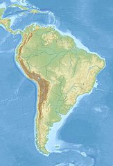
English: Relief location map of SouthAmerica.
|
| Dät | |
| Fon | Vobot okik |
| Lautan | Uwe Dedering |
Dälastad
I, the copyright holder of this work, hereby publish it under the following licenses:
This file is licensed under the Creative Commons Attribution-Share Alike 3.0 Unported license.
- Binol libik:
- to share – to copy, distribute and transmit the work
- to remix – to adapt the work
- Under the following conditions:
- attribution – You must give appropriate credit, provide a link to the license, and indicate if changes were made. You may do so in any reasonable manner, but not in any way that suggests the licensor endorses you or your use.
- share alike – If you remix, transform, or build upon the material, you must distribute your contributions under the same or compatible license as the original.

|
Däl pagevon ad kopiedön, seagivön e/u votükön dokümi at ma Dälazöt ad Dokümam Libik: GNU, Fomam: 1.2 u nulikum fa el Free Software Foundation (Stitod: Nünömaprograms libik); nen diläds nevotükovik, nen vödems tegapada balid, e leigo nen vödems tegapada lätik. Kopied dälazöta pekeninon in diläd: Dälazöt ad Dokümam Libik: GNU panemöl. |
You may select the license of your choice.
Jenotem ragiva
Välolös däti/timi ad logön ragivi soäsä äbinon ün tim at.
| Dät/Tim | Magodil | Mafots | Geban | Küpet | |
|---|---|---|---|---|---|
| anuik | 12:50, 2010 novul 27id | | 1,181 × 1,732 (1.71 MB) | Uwe Dedering | {{Information |Description={{en|1= Relief location map of SouthAmerica. * Projection: Lambert azimuthal equal-area projection. * Area of interest: :* N: 25.0° N :* S: -60.0° N :* W: -90.0° E :* E: -30.0° E * Projection center: :* NS: -17.5° N :* WE: |
Yüms
Pads nonik peyümons ad ragiv at.
Ragivigeb Valöpik
The following other wikis use this file:
- Geb su als.wikipedia.org
- Geb su ar.wikipedia.org
- Geb su ast.wikipedia.org
- Geb su av.wikipedia.org
- Geb su azb.wikipedia.org
- Geb su az.wikipedia.org
- And dağları
- Amazon çayı
- Robinzon Kruzo adası
- Aleksandr Selkirk adası
- Santa Klara adası
- Kopaue
- Şablon:Yer xəritəsi Cənubi Amerika
- İquiqe zəlzələsi (2014)
- İquasu Milli Parkı (Argentina)
- İquasu (şəlalə)
- Serra-du-Mar
- Magellan boğazı
- Dreyk boğazı
- Biql boğazı
- Valdivia zəlzələsi (1960)
- Grau dənizi
- Argentina dənizi
- Pataqoniya arxipelaqı
- Qalinas burnu
- Frоuаrd burnu
- Parinyas burnu
- Seyşas burnu
- Tietе
- Quayra şəlaləsi
- Lyulyaylyako milli parkı
- Kabu-Branku burnu
- Moça adası
- Benxamin adası
- Quamblin adası
- Ceyms adası (Çili)
- Viktoriya adası (Çili)
- Kuptana adası
- Melçor adası
- Rivero adası
- Trayqen adası
- San Ambrosio
- Doson adası
View more global usage of this file.