
Ragiv:Albany, New York Map.png
Size of this preview: 600 × 600 pixels. Other resolutions: 240 × 240 pixels • 480 × 480 pixels • 1,000 × 1,000 pixels.
Ragiv rigik (1,000 × 1,000 pixel, ragivagret: 509 KB, pated MIME: image/png)
Plän brefik
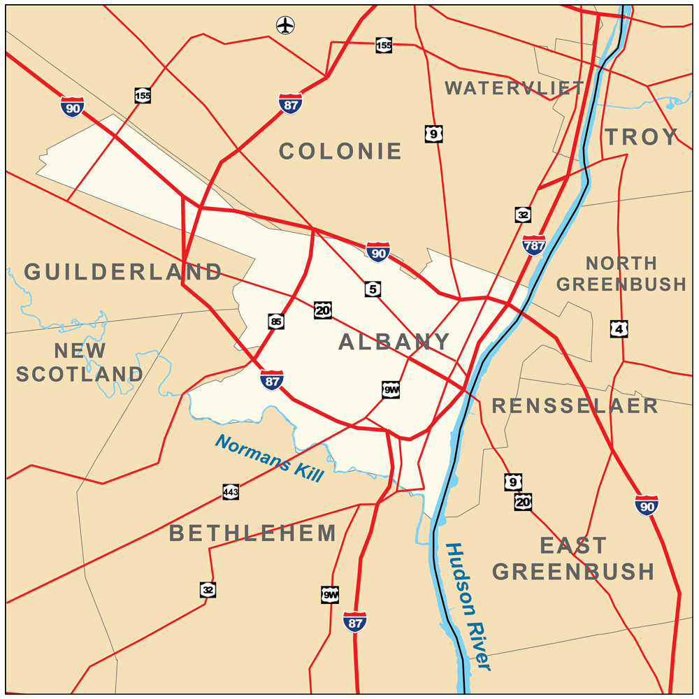
| Bepenam | Map of Albany, New York, United States. |
| Dät | |
| Fon |
Vobot okik. Township and county boundaries from the U.S. Census Bureau [1]; Rivers from the National Hydrography Dataset [2]; Roads from the National Atlas [3]. |
| Lautan | Kmusser |
| Other versions |
|


Dälastad
I, the copyright holder of this work, hereby publish it under the following license:
This file is licensed under the Creative Commons Attribution-Share Alike 3.0 Unported license.
- Binol libik:
- to share – to copy, distribute and transmit the work
- to remix – to adapt the work
- Under the following conditions:
- attribution – You must give appropriate credit, provide a link to the license, and indicate if changes were made. You may do so in any reasonable manner, but not in any way that suggests the licensor endorses you or your use.
- share alike – If you remix, transform, or build upon the material, you must distribute your contributions under the same or compatible license as the original.
Jenotem ragiva
Välolös däti/timi ad logön ragivi soäsä äbinon ün tim at.
| Dät/Tim | Magodil | Mafots | Geban | Küpet | |
|---|---|---|---|---|---|
| anuik | 15:32, 2010 mayul 11id | | 1,000 × 1,000 (509 KB) | Kmusser | more routes |
| 20:57, 2010 mayul 10id |  | 1,000 × 1,000 (490 KB) | Kmusser | == {{int:filedesc}} == {{Information |Description=Map of Albany, New York, United States. |Source={{own}}.</br>Township and county boundaries from the U.S. Census Bureau [http://www.census.gov/g |
Yüms
Pads sököl payümons ko pad at:
Ragivigeb Valöpik
The following other wikis use this file:
- Geb su ar.wikipedia.org
- Geb su arz.wikipedia.org
- Geb su ast.wikipedia.org
- Geb su azb.wikipedia.org
- Geb su ba.wikipedia.org
- Geb su bn.wikipedia.org
- Geb su ca.wikipedia.org
- Geb su ceb.wikipedia.org
- Geb su diq.wikipedia.org
- Geb su el.wikipedia.org
- Geb su en.wikipedia.org
- Geb su eo.wikipedia.org
- Geb su eu.wikipedia.org
- Geb su fa.wikipedia.org
- Geb su fr.wikipedia.org
- Geb su ga.wikipedia.org
- Geb su gl.wikipedia.org
- Geb su ht.wikipedia.org
- Geb su hu.wikipedia.org
- Geb su ia.wikipedia.org
- Geb su ilo.wikipedia.org
- Geb su kab.wikipedia.org
- Geb su la.wikipedia.org
- Geb su ml.wikipedia.org
- Geb su new.wikipedia.org
- Geb su ro.wikipedia.org
- Geb su sa.wikipedia.org
- Geb su sh.wikipedia.org
- Geb su simple.wikipedia.org
- Geb su sr.wikipedia.org
- Geb su sv.wikipedia.org
- Geb su th.wikipedia.org
- Geb su tl.wikipedia.org
- Geb su tt.wikipedia.org
- Geb su ur.wikipedia.org
- Geb su vi.wikipedia.org
- Geb su www.wikidata.org
- Geb su zh-min-nan.wikipedia.org
- Geb su zh.wikipedia.org