
Ragiv:Alpine, California western town limit sign (2010).jpg

Size of this preview: 800 × 600 pixels. Other resolutions: 320 × 240 pixels • 640 × 480 pixels • 1,024 × 768 pixels • 1,280 × 960 pixels • 2,560 × 1,920 pixels • 3,648 × 2,736 pixels.
Ragiv rigik (3,648 × 2,736 pixel, ragivagret: 4.92 MB, pated MIME: image/jpeg)
.jpg)
Plän brefik
| Bepenam |
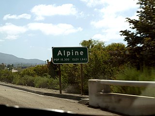
English: Western town limit sign for the census-designated place of Alpine, California as seen from the eastbound lane of Interstate 8 at the Dunbar Lane/Viewside Lane overpass. View looking southeast. This photograph was taken with an Olympus E-510 DSLR camera and edited (color balance, brightness, contrast, saturation, sharpness) using ArcSoft PhotoStudio 5.5 |
| Dät | |
| Fon | Vobot okik |
| Lautan | Amin Eshaiker |
| Däl (Reusing this file) |
If you use this photograph outside Wikimedia, I would highly appreciate if you let me know by email or on my talk page, as I'm curious where my work is used. |
| Camera location | | View this and other nearby images on: OpenStreetMap |
|---|
.jpg¶ms=032.856765_N_-116.819378_E_globe:Earth_type:camera_region:US-CA_scale:50_heading:135.00&language=vo)
| This is a retouched picture, which means that it has been digitally altered from its original version. Modifications: color balance, brightness, contrast, saturation, sharpness. Modifications made by Amineshaker.
|
Dälastad
I, the copyright holder of this work, hereby publish it under the following licenses:
This file is licensed under the Creative Commons Attribution-Share Alike 3.0 Unported license.
- Binol libik:
- to share – to copy, distribute and transmit the work
- to remix – to adapt the work
- Under the following conditions:
- attribution – You must give appropriate credit, provide a link to the license, and indicate if changes were made. You may do so in any reasonable manner, but not in any way that suggests the licensor endorses you or your use.
- share alike – If you remix, transform, or build upon the material, you must distribute your contributions under the same or compatible license as the original.

|
Däl pagevon ad kopiedön, seagivön e/u votükön dokümi at ma Dälazöt ad Dokümam Libik: GNU, Fomam: 1.2 u nulikum fa el Free Software Foundation (Stitod: Nünömaprograms libik); nen diläds nevotükovik, nen vödems tegapada balid, e leigo nen vödems tegapada lätik. Kopied dälazöta pekeninon in diläd: Dälazöt ad Dokümam Libik: GNU panemöl. |
You may select the license of your choice.
Jenotem ragiva
Välolös däti/timi ad logön ragivi soäsä äbinon ün tim at.
| Dät/Tim | Magodil | Mafots | Geban | Küpet | |
|---|---|---|---|---|---|
| anuik | 22:58, 2012 yanul 7id | | 3,648 × 2,736 (4.92 MB) | Amineshaker | {{Information |Description ={{en|1=Western town limit sign for the census-designated place of Alpine, California as seen from the eastbound lane of Interstate 8 at the Dunbar Lane/Viewside L |
Yüms
Pads sököl payümons ko pad at:
Ragivigeb Valöpik
The following other wikis use this file:
- Geb su azb.wikipedia.org
- Geb su ceb.wikipedia.org
- Geb su ce.wikipedia.org
- Geb su en.wikipedia.org
- Geb su es.wikipedia.org
- Geb su eu.wikipedia.org
- Geb su fa.wikipedia.org
- Geb su fr.wikipedia.org
- Geb su it.wikipedia.org
- Geb su lld.wikipedia.org
- Geb su nl.wikipedia.org
- Geb su nv.wikipedia.org
- Geb su pl.wikipedia.org
- Geb su pt.wikipedia.org
- Geb su sh.wikipedia.org
- Geb su sr.wikipedia.org
- Geb su tt.wikipedia.org
- Geb su uk.wikipedia.org
- Geb su www.wikidata.org
- Geb su zh-min-nan.wikipedia.org
- Geb su zh.wikipedia.org
.jpg)