
Ragiv:LocationIndia.png

Size of this preview: 800 × 370 pixels. Other resolutions: 320 × 148 pixels • 640 × 296 pixels • 1,357 × 628 pixels.
Ragiv rigik (1,357 × 628 pixel, ragivagret: 21 KB, pated MIME: image/png)

|
This locator map image could be re-created using vector graphics as an SVG file. This has several advantages; see Commons:Media for cleanup for more information. If an SVG form of this image is available, please upload it and afterwards replace this template with
{{vector version available|new image name}}.
It is recommended to name the SVG file “LocationIndia.svg”—then the template Vector version available (or Vva) does not need the new image name parameter. |
Plän brefik
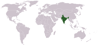
Location map for w:India.
User:dbenbenn modified Image:BlankMap-World.png.
Dälastad
| |
This work has been released into the public domain by its author, Vardion, at the Linglänapük Vükiped project. This applies worldwide. In case this is not legally possible: |
Jenotem ragiva
Välolös däti/timi ad logön ragivi soäsä äbinon ün tim at.
| Dät/Tim | Magodil | Mafots | Geban | Küpet | |
|---|---|---|---|---|---|
| anuik | 07:35, 2021 setul 11id | | 1,357 × 628 (21 KB) | Ytpks896 | Reverted to version as of 22:39, 12 February 2005 (UTC) |
| 13:37, 2021 yulul 29id |  | 1,427 × 628 (103 KB) | Ytpks896 | Reverted to version as of 03:16, 1 May 2008 (UTC) | |
| 00:33, 2010 febul 15id |  | 1,357 × 628 (24 KB) | King Zebu | Reverted to version as of 09:17, 3 June 2005 Please discuss before making such edits in future. | |
| 03:16, 2008 mayul 1id |  | 1,427 × 628 (103 KB) | KAVO | (Changed to colours more noticeable: *Light green - Claimed by India, not administered by India **(Aksai Chin, Azad Kashmir, Northern Areas, Shaksgam Valley) *Deep Green - Disputed with other nations, administered by India **(Arunachal Pradesh, Jammu and | |
| 09:17, 2005 yunul 3id |  | 1,357 × 628 (24 KB) | Nichalp | NPOV map, please discuss any changes with me for NPOV status | |
| 22:39, 2005 febul 12id |  | 1,357 × 628 (21 KB) | Dbenbenn | higher resolution version, without black border | |
| 20:28, 2004 dekul 5id |  | 250 × 115 (18 KB) | EugeneZelenko | Location map for India.<br/>Originally created for English Wikipedia by Vardion.<br/>{{GFDL}} |
Yüms
Pads nonik peyümons ad ragiv at.
Ragivigeb Valöpik
The following other wikis use this file:
- Geb su ar.wikinews.org
- Geb su ckb.wikipedia.org
- Geb su en.wikipedia.org
- Geb su en.wikinews.org
- Geb su en.wikivoyage.org
- Geb su en.wiktionary.org
- Geb su fr.wikinews.org
- Geb su fur.wikipedia.org
- Geb su he.wikivoyage.org
- Geb su hr.wikipedia.org
- Geb su hr.wikiquote.org
- Geb su incubator.wikimedia.org
- Geb su ko.wikipedia.org
- Geb su li.wikinews.org
- Geb su pam.wikipedia.org
- Geb su pl.wiktionary.org
- Geb su ps.wikivoyage.org
- Geb su pt.wikivoyage.org
- Geb su pt.wiktionary.org
- Geb su sr.wikibooks.org
- Geb su sv.wikinews.org
View more global usage of this file.