
Ragiv:Loos-en-Gohelle - Terrils n° 74, 74A et 74B, 11 - 19 de Lens Est, Ouest et Nouveau (047).JPG

Size of this preview: 800 × 600 pixels. Other resolutions: 320 × 240 pixels • 640 × 480 pixels • 1,024 × 768 pixels • 1,280 × 960 pixels • 2,560 × 1,920 pixels • 3,648 × 2,736 pixels.
Ragiv rigik (3,648 × 2,736 pixel, ragivagret: 3.92 MB, pated MIME: image/jpeg)
Plän brefik
| Bepenam |
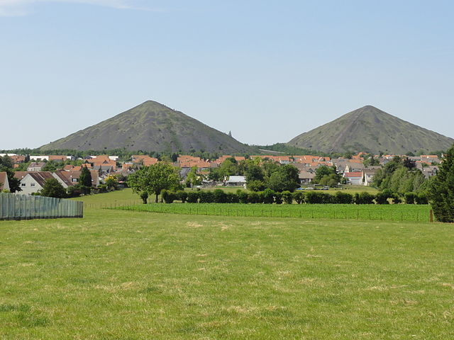
Français : Terrils nos 74, 74A et 74B respectivement dénommés 11 - 19 de Lens Est, 11 - 19 de Lens Ouest et 11 - 19 de Lens Nouveau, fosse n° 11 - 19 de la Compagnie des mines de Lens dans le bassin minier du Nord-Pas-de-Calais, Loos-en-Gohelle, Pas-de-Calais, Nord-Pas-de-Calais, France. Les terrils nos 74, 74A et 74B sont inscrits sur la liste du patrimoine mondial de l'Unesco le 30 juin 2012 et y constituent en partie le site no 63. |
|||||||
| Dät | ||||||||
| Fon | Vobot okik | |||||||
| Lautan | Jérémy Jännick | |||||||
| Däl (Reusing this file) |
| |||||||
| Attribution (required by the license) | Jérémy-Günther-Heinz Jähnick / Loos-en-Gohelle - Terrils n° 74, 74A et 74B, 11 - 19 de Lens Est, Ouest et Nouveau (047) / Wikimedia Commons / | |||||||

.JPG)
| Camera location | | View this and other nearby images on: OpenStreetMap |
|---|
.JPG¶ms=050.427533_N_0002.750556_E_globe:Earth_type:camera__&language=vo)
Jenotem ragiva
Välolös däti/timi ad logön ragivi soäsä äbinon ün tim at.
| Dät/Tim | Magodil | Mafots | Geban | Küpet | |
|---|---|---|---|---|---|
| anuik | 13:17, 2011 yunul 7id | | 3,648 × 2,736 (3.92 MB) | Jérémy-Günther-Heinz Jähnick |
Yüms
Pads sököl payümons ko pad at:
Ragivigeb Valöpik
The following other wikis use this file:
- Geb su ar.wikipedia.org
- Geb su arz.wikipedia.org
- Geb su ast.wikipedia.org
- Geb su br.wikipedia.org
- Geb su ca.wikipedia.org
- Geb su ce.wikipedia.org
- Geb su de.wikipedia.org
- Geb su diq.wikipedia.org
- Geb su eo.wikipedia.org
- Geb su es.wikipedia.org
- Geb su eu.wikipedia.org
- Geb su fr.wikipedia.org
- Geb su hu.wikipedia.org
- Geb su it.wikipedia.org
- Geb su ku.wikipedia.org
- Geb su la.wikipedia.org
- Geb su lld.wikipedia.org
- Geb su nl.wikipedia.org
- Geb su oc.wikipedia.org
- Geb su pcd.wikipedia.org
- Geb su pl.wikipedia.org
- Geb su pms.wikipedia.org
- Geb su pt.wikipedia.org
- Geb su ro.wikipedia.org
- Geb su sk.wikipedia.org
- Geb su sv.wikipedia.org
- Geb su tt.wikipedia.org
- Geb su uk.wikipedia.org
- Geb su vec.wikipedia.org
- Geb su www.wikidata.org
- Geb su zh-min-nan.wikipedia.org
- Geb su zh.wikipedia.org
.JPG)