
Ragiv:Panorama - Capo di Ponte (Foto Luca Giarelli).jpg

Size of this preview: 800 × 600 pixels. Other resolutions: 320 × 240 pixels • 640 × 480 pixels • 1,024 × 768 pixels.
Ragiv rigik (1,024 × 768 pixel, ragivagret: 740 KB, pated MIME: image/jpeg)
Plän brefik
| Bepenam |
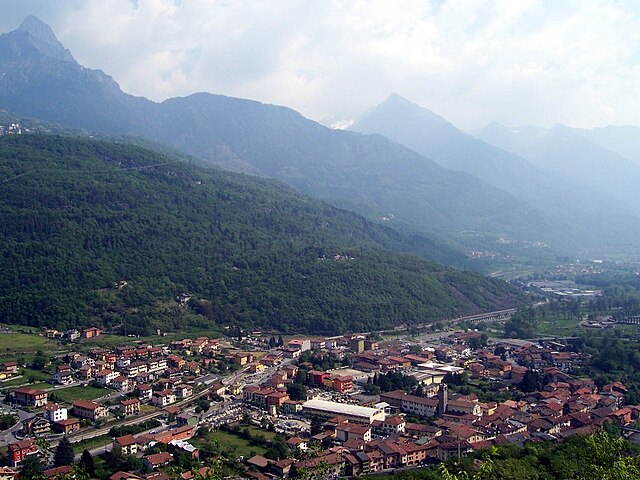
Italiano: Capo di Ponte, Val Camonica, Italia |
||||
| Dät | |||||
| Fon | Vobot okik | ||||
| Lautan | Luca Giarelli | ||||
| Däl (Reusing this file) |
I, the copyright holder of this work, hereby publish it under the following license: This file is licensed under the Creative Commons Attribution-Share Alike 3.0 Unported license.
|
.jpg)
.jpg)
| Object location | | View this and other nearby images on: OpenStreetMap |
|---|
.jpg¶ms=046.028885_N_0010.341670_E_globe:Earth_class:object_type:object__&language=vo)
| Camera location | | View this and other nearby images on: OpenStreetMap |
|---|
.jpg¶ms=046.031667_N_0010.346111_E_globe:Earth_type:camera_region:IT_type:landmark_&language=vo)
Jenotem ragiva
Välolös däti/timi ad logön ragivi soäsä äbinon ün tim at.
| Dät/Tim | Magodil | Mafots | Geban | Küpet | |
|---|---|---|---|---|---|
| anuik | 17:41, 2016 tobul 24id | | 1,024 × 768 (740 KB) | Walter Giannetti | Bilanciamento del bianco |
| 00:16, 2009 yanul 27id |  | 1,024 × 768 (218 KB) | Erik Baas | Reverted to version as of 14:48, 31 December 2007 - removed watermark. | |
| 11:12, 2008 novul 20id |  | 1,024 × 768 (111 KB) | Lord Hidelan | {{Information |Description= |Source= |Date= |Author= |Permission= |other_versions= }} | |
| 14:48, 2007 dekul 31id |  | 1,024 × 768 (218 KB) | Lord Hidelan | {{Information |Description= Capo di Ponte, Val Camonica, Italia |Source=Luca [http://it.wikipedia.org/wiki/Giarelli Giarelli] (self-made) |Date= 2007 |Author= [http://it.wikipedia.org/wiki/Utente:Lord_Hidelan Lord Hidelan] }} Category:Val Camonica |
Yüms
Pads sököl payümons ko pad at:
Ragivigeb Valöpik
The following other wikis use this file:
- Geb su azb.wikipedia.org
- Geb su bg.wikipedia.org
- Geb su br.wikipedia.org
- Geb su ceb.wikipedia.org
- Geb su ce.wikipedia.org
- Geb su el.wikipedia.org
- Geb su en.wikipedia.org
- Geb su eo.wikipedia.org
- Geb su es.wikipedia.org
- Geb su eu.wikipedia.org
- Geb su fa.wikipedia.org
- Geb su fi.wikipedia.org
- Geb su fr.wikipedia.org
- Geb su he.wikipedia.org
- Geb su hu.wikipedia.org
- Geb su hy.wikipedia.org
- Geb su ia.wikipedia.org
- Geb su it.wikipedia.org
- Geb su it.wikivoyage.org
- Geb su ja.wikipedia.org
- Geb su la.wikipedia.org
- Geb su lij.wikipedia.org
- Geb su lld.wikipedia.org
- Geb su lmo.wikipedia.org
- Geb su nl.wikipedia.org
- Geb su pl.wikipedia.org
- Geb su pms.wikipedia.org
- Geb su pt.wikipedia.org
- Geb su roa-tara.wikipedia.org
- Geb su ro.wikipedia.org
- Geb su sr.wikipedia.org
- Geb su sv.wikipedia.org
- Geb su tl.wikipedia.org
- Geb su tr.wikipedia.org
- Geb su tt.wikipedia.org
- Geb su uk.wikipedia.org
- Geb su uz.wikipedia.org
- Geb su vec.wikipedia.org
- Geb su vi.wikipedia.org
- Geb su www.wikidata.org
.jpg)