
Ragiv:Philadelphia skyline from South Street Bridge January 2020 (rotate 2 degrees perspective correction crop 4-1).jpg

Size of this preview: 800 × 200 pixels. Other resolutions: 320 × 80 pixels • 640 × 160 pixels • 1,024 × 256 pixels • 3,816 × 954 pixels.
Ragiv rigik (3,816 × 954 pixel, ragivagret: 1.42 MB, pated MIME: image/jpeg)
Plän brefik
| Bepenam |
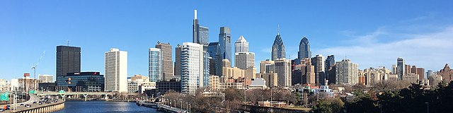
English: The skyline of Philadelphia, Pennsylvania viewed from the South Street Bridge over the Schuylkill River. If on Wikipedia, see the fully annotated version on the Wikimedia page.
|
||
| Dät | |||
| Fon | File:Philadelphia_skyline_from_South_Street_Bridge_January_2020.jpeg | ||
| Lautan | Dough4872; modifications and annotations by Maps and stuff (Brian W. Schaller) | ||
| Other versions |
|

.jpg)
| Camera location | | View this and other nearby images on: OpenStreetMap |
|---|
.jpg¶ms=039.946975_N_-075.186797_E_globe:Earth_type:camera_heading:69.51&language=vo)
Dälastad
This file is licensed under the Creative Commons Attribution-Share Alike 4.0 International license.
- Binol libik:
- to share – to copy, distribute and transmit the work
- to remix – to adapt the work
- Under the following conditions:
- attribution – You must give appropriate credit, provide a link to the license, and indicate if changes were made. You may do so in any reasonable manner, but not in any way that suggests the licensor endorses you or your use.
- share alike – If you remix, transform, or build upon the material, you must distribute your contributions under the same or compatible license as the original.
| Annotations | This image is annotated: View the annotations at Commons |
Jenotem ragiva
Välolös däti/timi ad logön ragivi soäsä äbinon ün tim at.
| Dät/Tim | Magodil | Mafots | Geban | Küpet | |
|---|---|---|---|---|---|
| anuik | 14:22, 2020 yanul 27id | 3,816 × 954 (1.42 MB) | Maps and stuff | User created page with UploadWizard |
Yüms
Pads sököl payümons ko pad at:
Ragivigeb Valöpik
The following other wikis use this file:
- Geb su ang.wikipedia.org
- Geb su ar.wikipedia.org
- Geb su arz.wikipedia.org
- Geb su ast.wikipedia.org
- Geb su br.wikipedia.org
- Geb su ca.wikipedia.org
- Geb su ce.wikipedia.org
- Geb su ckb.wikipedia.org
- Geb su cy.wikipedia.org
- Geb su da.wikipedia.org
- Geb su de.wikivoyage.org
- Geb su diq.wikipedia.org
- Geb su en.wikipedia.org
- Geb su en.wikibooks.org
- Geb su en.wikivoyage.org
- Geb su eu.wikipedia.org
- Geb su fr.wikivoyage.org
- Geb su ga.wikipedia.org
- Geb su gl.wikipedia.org
- Geb su ha.wikipedia.org
- Geb su he.wikivoyage.org
- Geb su ht.wikipedia.org
- Geb su ia.wikipedia.org
- Geb su ilo.wikipedia.org
- Geb su incubator.wikimedia.org
- Geb su it.wikipedia.org
- Geb su it.wikivoyage.org
- Geb su ja.wikivoyage.org
- Geb su kab.wikipedia.org
- Geb su lb.wikipedia.org
- Geb su lld.wikipedia.org
- Geb su mhr.wikipedia.org
- Geb su no.wikipedia.org
- Geb su ru.wikipedia.org
- Geb su ru.wikinews.org
- Geb su simple.wikipedia.org
View more global usage of this file.
.jpg)
.jpg)