
Ragiv:St. Johns, Arizona (101310387).jpg

Ragiv rigik (1,600 × 1,200 pixel, ragivagret: 610 KB, pated MIME: image/jpeg)
.jpg)
Plän brefik
| Bepenam |
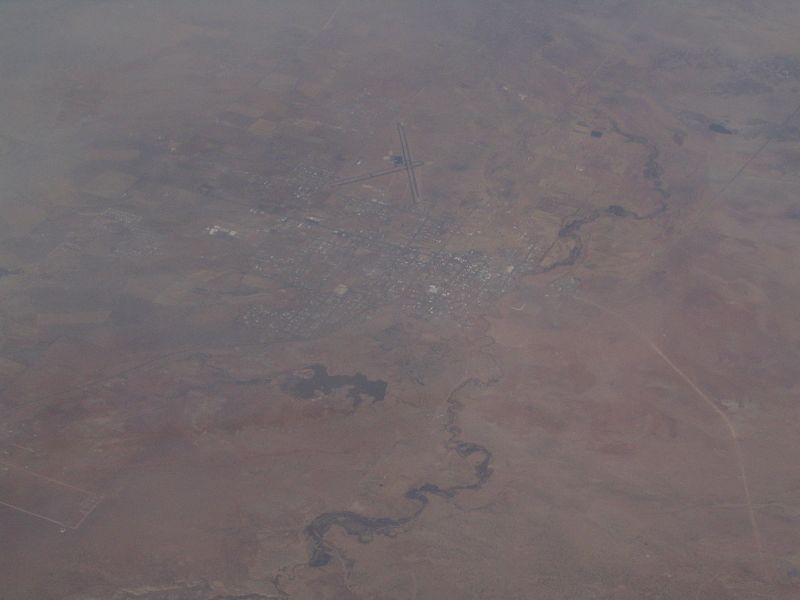
St. Johns is the only city in and the county seat of Apache County, Arizona, United States. It is located along U.S. Route 180, mostly west of where that highway intersects with U.S. Route 191. According to 2006 Census Bureau estimates, the population of the city was 3,538. St. Johns was first settled in 1873 by the Barth Brothers. They were bought out in 1879 by Ammon M. Tenney. St. Johns has been the county seat for almost all of the county's history. When the county was created on February 24, 1879, Snowflake was designated the county seat. After the first election in fall 1879, county government was set up in St. Johns, though it was moved again in 1880, to Springerville; in 1882 St. Johns again became the county seat, and it has remained so ever since. St. Johns is home to the Apache County Historical Society Museum and has four National Register of Historic Places: Isaacson Building, Lower Zuni River Archeological District, Lyman Lake Rock Art Site, and Rattlesnake Point Pueblo. St. Johns is near the Placerias Quarry, the site where dozens of Placerias fossils were discovered in 1930 by Charles Camp and Samuel Welles, of the University of California, Berkeley. St. Johns is along the shortest and most scenic route from Phoenix to Albuquerque, New Mexico. Within an hour's drive from St. John's are Apache-Sitgreaves National Forest, Petrified Forest National Park, the Painted Desert, and Lyman Lake State Park, as well as Indian reservations such as the Navajo Nation, Fort Apache Indian Reservation, San Carlos Apache Indian Reservation, and Zuni Indian Reservation. en.wikipedia.org/wiki/St._Johns,_Arizona en.wikipedia.org/wiki/Wikipedia:Text_of_Creative_Commons_... |
| Dät | |
| Fon | St. Johns, Arizona |
| Lautan | Ken Lund from Reno, Nevada, USA |
| Camera location | | View this and other nearby images on: OpenStreetMap |
|---|
.jpg¶ms=034.506910_N_-109.361858_E_globe:Earth_type:camera_source:Flickr_&language=vo)
Dälastad
- Binol libik:
- to share – to copy, distribute and transmit the work
- to remix – to adapt the work
- Under the following conditions:
- attribution – You must give appropriate credit, provide a link to the license, and indicate if changes were made. You may do so in any reasonable manner, but not in any way that suggests the licensor endorses you or your use.
- share alike – If you remix, transform, or build upon the material, you must distribute your contributions under the same or compatible license as the original.
| This image was originally posted to Flickr by Ken Lund at https://flickr.com/photos/75683070@N00/101310387. It was reviewed on 3 dekul 2015 by FlickreviewR and was confirmed to be licensed under the terms of the cc-by-sa-2.0. |
Jenotem ragiva
Välolös däti/timi ad logön ragivi soäsä äbinon ün tim at.
| Dät/Tim | Magodil | Mafots | Geban | Küpet | |
|---|---|---|---|---|---|
| anuik | 21:43, 2015 dekul 3id | | 1,600 × 1,200 (610 KB) | INeverCry | Transferred from Flickr via Flickr2Commons |
Yüms
Pads sököl payümons ko pad at:
Ragivigeb Valöpik
The following other wikis use this file:
- Geb su ar.wikipedia.org
- Geb su arz.wikipedia.org
- Geb su bg.wikipedia.org
- Geb su ca.wikipedia.org
- Geb su ceb.wikipedia.org
- Geb su ce.wikipedia.org
- Geb su cy.wikipedia.org
- Geb su es.wikipedia.org
- Geb su eu.wikipedia.org
- Geb su he.wikipedia.org
- Geb su ht.wikipedia.org
- Geb su hu.wikipedia.org
- Geb su it.wikipedia.org
- Geb su lld.wikipedia.org
- Geb su no.wikipedia.org
- Geb su pl.wikipedia.org
- Geb su pt.wikipedia.org
- Geb su ro.wikipedia.org
- Geb su sr.wikipedia.org
- Geb su tt.wikipedia.org
- Geb su uz.wikipedia.org
- Geb su www.wikidata.org
.jpg)