
Saint-Christophe-de-Valains
| Saint-Christophe-de-Valains | |
|---|---|
 | |
 Topam in topäd: Bretän, in Fransän. | |
| Topam | |
| Län | |
| Topäd | Bretän |
| Ziläk | Ille-et-Vilaine[*], Fougères Agglomération[*], arrondissement of Fougères-Vitré[*], arrondissement of Fougères[*] |
| Nüns cifik | |
| Lödanef | 234 |
| Sürfat | 3.27 kvadamilmet |
| Geilot zänedik | 75 m, 35 m, 104 m sus melanivod |
| Nüns votik | |
| Kot ela ,INSEE’ | 35261 |
| Potakot | 35140 |
| Bevüresod | http://saintchristophedevalains.fr |
_Mairie_-_01.jpg)
| |
Saint-Christophe-de-Valains binon zif in ziläk: Ille-et-Vilaine, in topäd: Bretän, in Fransän. Saint-Christophe-de-Valains topon videtü 48°20’ 37’’ N e lunetü 1°26’ 45’’ V.
Sürfat ela Saint-Christophe-de-Valains binon mö 3,27 km².
Saint-Christophe-de-Valains labon belödanis 186 (2008).
koordinats: 48°20’ 37’’N 1°26’ 45’’V / 48.34361°N 1.44583°W
-
 Saint-Christophe-de-Valains
 -
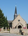 Church of Saint-Christophe-de-Valains
 -
 Saint-Christophe-de-Valains
 -
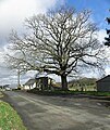 The Liberty Oak.
 -
 The war memorial.
 -
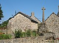
 Memorial stone.
 -
 Flood of January 4, 1936.


_Ch%C3%AAne_de_la_Libert%C3%A9_01.jpg)


